
Florida Faces Rare Arctic Blast as Wind Chills Crash Into Single Digits From Panhandle to North Florida
FLORIDA — A powerful Arctic air mass is set to plunge into the state early Sunday morning, driving dangerously low wind chill values across large portions of Florida — including areas that rarely experience true cold stress.
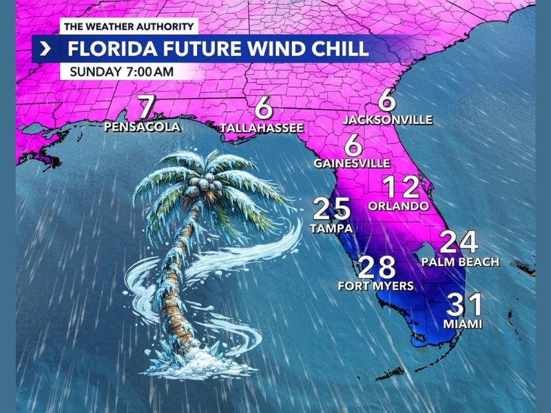
According to forecast data, feels-like temperatures will fall into the single digits across North Florida, with widespread 20s and lower 30s extending deep into Central and South Florida. Meteorologists describe this outbreak as one of the most intense cold snaps to impact the state in recent years.
Wind Chill Forecast: Sunday Morning at 7 A.M.
The coldest wind chills are expected around sunrise Sunday, when strong northerly winds combine with frigid air:
- Tallahassee: feels like 6°F
- Gainesville: feels like 6°F
- Jacksonville: feels like 6°F
- Pensacola: feels like 7°F
- Orlando: feels like 12°F
- Tampa: feels like 25°F
- Palm Beach: feels like 24°F
- Fort Myers: feels like 28°F
- Miami: feels like 31°F
These values reflect wind chill, not actual air temperature — but the human body responds to wind chill as real cold, significantly increasing the risk of cold-related stress.
Why This Cold Is So Unusual for Florida
Florida rarely experiences Arctic air masses of this strength, especially ones that penetrate so far south. In this case, a deep surge of polar air is plunging directly down the eastern United States, overwhelming the typical moderating influence of the Gulf of Mexico.
Even South Florida, which typically avoids the worst of winter cold, is expected to feel unseasonably harsh conditions by Florida standards.
What Residents Should Prepare For
This cold event poses risks that many Floridians are not accustomed to dealing with:
- Cold stress for people spending extended time outdoors
- Danger to pets, especially overnight and early morning
- Threats to sensitive plants and crops
- Increased strain on heating systems not designed for extreme cold
Residents are urged to limit early-morning outdoor exposure, protect pets and plants, and check on vulnerable individuals.
Bottom Line
This is not a typical cool Florida morning. Single-digit wind chills in North Florida are serious, and even areas farther south will feel shockingly cold compared to normal winter conditions. The worst of the cold is expected early Sunday, with gradual improvement later in the day as winds ease.
For continued coverage of major weather events affecting the U.S., stay connected with NapervilleLocal.com and check back for further updates as conditions evolve.

I’ve lived in Naperville long enough to see how quickly our community changes — from new developments downtown to sudden shifts in our Midwest weather. Reporting on Naperville news and daily forecasts gives me the chance to keep neighbors informed about what really matters. My goal is simple: deliver clear, timely updates so you always know what’s happening in our city and what to expect from the skies above.