
Florida Georgia South Carolina North Carolina Southeast Faces Dry Week as Atlantic Storm Moisture Stays Offshore Limiting Rainfall Chances
SOUTHEAST UNITED STATES — A new 7-day rainfall outlook is pointing toward largely dry conditions across much of the Southeast, including Florida, Georgia, and the Carolinas, as the bulk of storm moisture remains offshore in the Atlantic.
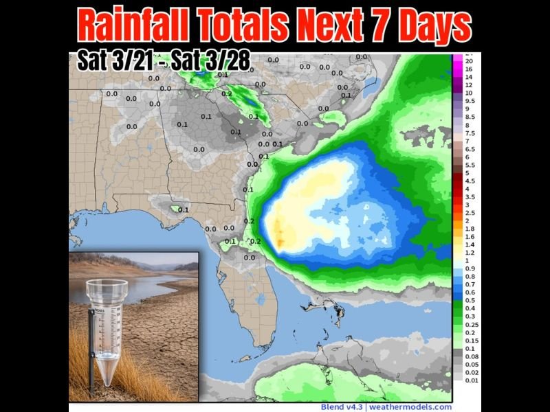
Offshore System Keeps Heaviest Rain Away
Forecast models show a significant concentration of rainfall staying well off the Southeast coastline, particularly east of Florida and the Atlantic seaboard. The heaviest precipitation is projected to remain over open waters, limiting widespread rainfall inland.
This offshore setup means that areas hoping for meaningful rain may once again come up short, especially across the Florida Peninsula.
Florida Peninsula Sees Limited Rain Chances
Earlier projections hinted at potential midweek rainfall across Florida, but updated model trends show decreasing chances. Most areas across the peninsula are now expected to receive little to no measurable precipitation over the next seven days.
Some isolated pockets may pick up light amounts — generally around 0.1 to 0.2 inches — but these totals are unlikely to provide significant relief.
Georgia and Carolinas Also Trending Dry
The dry pattern extends northward into Georgia and the Carolinas, where rainfall totals are expected to remain minimal. Many locations across these states are projected to receive less than a tenth of an inch of rain through the forecast period.
A few scattered showers could develop, but widespread or soaking rainfall appears unlikely at this time.
Interior Southeast and Gulf Coast Conditions
Across parts of Alabama, Mississippi, and nearby Gulf Coast regions, rainfall totals are also expected to remain limited. Most inland areas are forecast to stay under 0.1 inches, reinforcing the broader dry trend across the region.
This lack of precipitation may contribute to increasing dryness in soils, particularly if the pattern persists beyond the current outlook window.
Why the Pattern Matters
The positioning of the offshore system is a key factor in this forecast. With moisture and energy remaining over the Atlantic instead of moving inland, rain opportunities are being suppressed across much of the Southeast.
This setup is not uncommon during transitional seasons, but it can quickly lead to concerns if dry conditions linger for extended periods.
What to Watch in the Coming Days
Forecasters will continue monitoring any potential shifts in the offshore system. A slight westward movement could bring increased rain chances back to the coast, particularly for Florida and the Carolinas.
For now, however, umbrellas may not see much use across the Southeast, with dry weather expected to dominate through the upcoming week.
As the pattern evolves, residents across Florida and neighboring states should stay alert for updates, especially if forecast models begin trending wetter in future runs.

I’ve lived in Naperville long enough to see how quickly our community changes — from new developments downtown to sudden shifts in our Midwest weather. Reporting on Naperville news and daily forecasts gives me the chance to keep neighbors informed about what really matters. My goal is simple: deliver clear, timely updates so you always know what’s happening in our city and what to expect from the skies above.