
Florida Panhandle Could See Rare Light Snow Sunday as Arctic Front Pushes Deep Into the Southeast
FLORIDA — A strong Arctic cold front moving into the southeastern United States this weekend could bring a rare chance of light snow accumulation to parts of the Florida Panhandle on Sunday, according to current forecast model guidance.
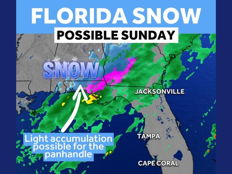
Weather models show cold air pushing far enough south to overlap with moisture near the Gulf Coast, creating a narrow window where snow could mix in or briefly accumulate, primarily across northwestern Florida near the Panhandle region.
What the Current Forecast Shows
The latest guidance indicates:
- Light snow is possible Sunday across parts of the Florida Panhandle
- Accumulations, if they occur, would be minor and localized
- The setup depends on precise timing between cold air and moisture
Meteorologists emphasize that this is not a guaranteed snow event, but rather a low-probability scenario driven by an unusually strong cold front for mid-January.
Where Snow Is — and Is Not — Expected
Based on the available data:
- Best chance: Florida Panhandle
- No snow expected: South Florida, including Southwest Florida
- Cities such as Jacksonville, Tampa, Cape Coral, and Miami are expected to remain rain-only or dry
This sharp north-south cutoff highlights how sensitive the setup is to small temperature changes.
Why This Setup Is Unusual for Florida
Snow in Florida is rare, especially this far south, but it becomes possible when:
- Arctic air plunges deeply southward
- Cold air arrives fast enough to undercut moisture
- Surface temperatures briefly fall to near-freezing levels
Even then, impacts are usually short-lived and confined to a small area.
What Happens Next
Forecast confidence will improve as the cold front approaches and high-resolution models better resolve the interaction between temperature and precipitation. Residents in the Florida Panhandle should monitor updates closely, especially if travel is planned early Sunday.
A strong Arctic front may briefly open the door for light snow in the Florida Panhandle on Sunday, while the rest of Florida stays snow-free. Any accumulation would be limited, but even the possibility underscores how unusually cold this pattern is for the Deep South.
For continued coverage of significant national and regional weather developments, follow updates from NapervilleLocal.com as forecast clarity improves.

I’ve lived in Naperville long enough to see how quickly our community changes — from new developments downtown to sudden shifts in our Midwest weather. Reporting on Naperville news and daily forecasts gives me the chance to keep neighbors informed about what really matters. My goal is simple: deliver clear, timely updates so you always know what’s happening in our city and what to expect from the skies above.