
Florida Severe Weather Monday Threat Targets Tallahassee, Tampa, Orlando and Daytona With Damaging Winds, Hail and Possible Tornado
TALLAHASSEE, FLORIDA — A round of potentially dangerous storms is expected to sweep across Florida on Monday, bringing the risk of damaging winds, hail, intense lightning, and even brief tornadoes as the system moves across the state from north to south.
Meteorologists warn that storms could develop rapidly across multiple regions of Florida throughout the day, with the strongest activity expected to move from the Panhandle through central Florida before reaching southern parts of the state by evening.
Communities including Tallahassee, Tampa, Orlando, Daytona, Palm Bay, and Miami could experience strong thunderstorms as the weather system advances across the peninsula.
Severe Storms Expected to Spread Across Florida
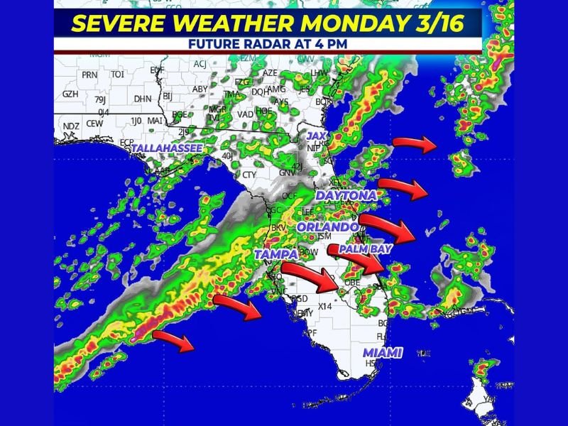
Forecast radar projections show clusters of storms forming across northern Florida before spreading southeast across the state.
The system appears to organize into several bands of thunderstorms stretching from the Gulf Coast toward the Atlantic coast, bringing heavy rain and lightning to large portions of Florida.
Cities most likely to see storm activity include:
- Tallahassee
- Tampa
- Orlando
- Daytona
- Palm Bay
- Miami
Storm bands shown on forecast radar indicate storms may move from the Gulf of Mexico toward the Florida Peninsula, gradually spreading eastward through the afternoon.
North Florida Faces Midday Storm Risk
The severe weather threat will begin earlier in the day across northern Florida. Meteorologists say numerous severe thunderstorms could develop around midday, particularly near the Tallahassee region and surrounding areas in the Panhandle.
These storms may produce strong wind gusts, dangerous lightning, and heavy rainfall capable of reducing visibility and causing localized flooding.
Central Florida Storms Expected During Afternoon
As the weather system moves southward, central Florida could see severe storms develop during the afternoon hours. Cities including Tampa, Orlando, Daytona, and Palm Bay are expected to experience thunderstorms capable of producing damaging winds and hail.
Storms moving through central Florida could also generate intense lightning and isolated brief tornadoes as atmospheric conditions become more unstable. Travel during the afternoon may become hazardous if strong storms develop along major highways across the region.
South Florida Storm Risk Lower but Still Possible
By the evening and nighttime hours, the storm system is expected to reach southern Florida.
Cities such as Miami and surrounding communities may still see thunderstorms, although the severe weather threat is expected to be lower compared to northern and central Florida. Even so, forecasters caution that lightning, heavy rainfall, and gusty winds remain possible across the region.
Outdoor Activities Could Increase Risk
One of the biggest concerns for meteorologists is that many people may be outdoors when storms develop, particularly near Florida’s beaches or during afternoon travel.
Because storms could form quickly, individuals outside or far from shelter may be vulnerable to lightning or sudden wind gusts. Officials recommend monitoring weather alerts and planning ahead if outdoor activities are scheduled.
Residents Urged to Prepare for Rapidly Changing Weather
Emergency officials encourage Florida residents to remain weather aware throughout Monday.
Recommended safety steps include:
- Monitoring weather alerts throughout the day
- Seeking shelter immediately if storms approach
- Avoiding beaches or open areas during lightning
- Ensuring weather warnings can be received quickly
Severe thunderstorms can develop quickly and produce dangerous conditions even if tornadoes do not occur.
Storm System Expected to Move Through Florida by Night
Forecasters expect the storm system to move across Florida during the day and into the evening hours, gradually pushing offshore by late night.
Residents across the state should stay alert for severe weather warnings as the storms develop. This report follows the editorial structure required for NapervilleLocal.com weather coverage standards .

I’ve lived in Naperville long enough to see how quickly our community changes — from new developments downtown to sudden shifts in our Midwest weather. Reporting on Naperville news and daily forecasts gives me the chance to keep neighbors informed about what really matters. My goal is simple: deliver clear, timely updates so you always know what’s happening in our city and what to expect from the skies above.