
Florida Snow Potential Emerges Again as Arctic Front and Jet Stream Shift Raise Sunday Winter Weather Risk
Florida — A rapidly changing jet stream pattern is raising fresh questions about whether parts of Florida could see snow for a second consecutive winter, as forecast data now shows a stronger and more moisture-laden arctic front approaching the region on Sunday.
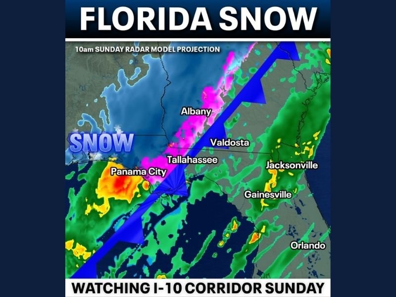
Meteorologists are closely watching the setup, which suggests cold air arriving faster and deeper than initially expected, increasing the chance for snow in the air across north Florida and the Panhandle, with some guidance even hinting at localized accumulation if conditions align.
Why the Snow Signal Is Gaining Attention
The latest forecast trend highlights a notable shift in the jet stream, allowing arctic air to plunge farther south while overlapping with increasing moisture. This combination is rare for Florida but not unprecedented.
Key factors driving the concern include:
- A stronger arctic cold front than earlier projections
- Improved moisture availability, increasing wintry precipitation potential
- Timing that places the coldest air directly over north Florida
While not every model agrees on accumulation, confidence is growing that at least snowflakes in the air are possible, particularly along the I-10 corridor.
Areas Most at Risk on Sunday
Forecast projections focus attention on north Florida and the Panhandle, including communities near and north of Tallahassee. As the front moves through, colder air could briefly overwhelm surface temperatures, especially during heavier precipitation bursts.
Potential outcomes range from:
- Snow mixing in with rain
- Brief periods of wet snow
- Isolated accumulation, mainly on grassy or elevated surfaces
Farther south, temperatures are expected to remain too warm for snow, though cold rain and gusty conditions are likely.
What This Could Mean for Travel and Daily Activity
Even a minor snow event in Florida can cause outsized impacts, particularly in regions unaccustomed to winter weather. If snow materializes, residents could see:
- Travel slowdowns, especially on bridges and overpasses
- School or schedule disruptions if conditions worsen overnight
- Rapidly changing road conditions during heavier precipitation
Forecasters caution that small temperature changes could significantly alter outcomes, making last-minute updates especially important.
Forecast Still Evolving, Monitoring Continues
Meteorologists emphasize that this is not a locked forecast, and trends could still shift before Sunday. However, the increasing agreement on colder air and moisture overlap has elevated the situation from novelty to something worth serious monitoring. Additional model data through Thursday will help determine whether this remains a snow-in-the-air scenario or evolves into something more impactful.
For continued coverage of developing winter weather threats, forecast explanations, and regional updates, follow ongoing reports from NapervilleLocal.com, where we track significant national weather patterns and explain why they matter.

I’ve lived in Naperville long enough to see how quickly our community changes — from new developments downtown to sudden shifts in our Midwest weather. Reporting on Naperville news and daily forecasts gives me the chance to keep neighbors informed about what really matters. My goal is simple: deliver clear, timely updates so you always know what’s happening in our city and what to expect from the skies above.