
Florida Snow Tease Continues as Models Keep Hinting at Sunday Morning Flurries Despite Growing Doubt
FLORIDA — Snow talk just won’t go away across the Southeast, even as official forecasts grow quieter. While many National Weather Service discussions have dialed back expectations, several major weather models continue to toy with the idea of light snow or flurries early Sunday, keeping meteorologists — and snow chasers — watching closely. The result? A forecast that feels more like educated guesswork than certainty.
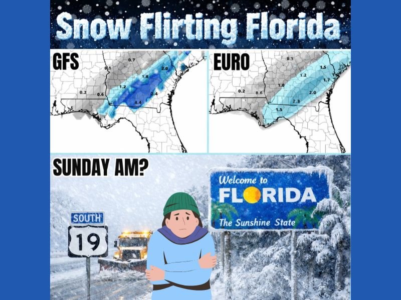
Why Snow Keeps Appearing in the Models
Despite skepticism from many forecasters, computer models have repeatedly sniffed out a narrow window where cold air and moisture briefly overlap across parts of the Deep South.
Both the GFS and EURO have shown versions of this setup, with light snow signals stretching from Florida into Georgia, though each run shifts placement and intensity. These aren’t blockbuster totals, and no one is suggesting a repeat of last year — but snow is snow, especially this far south. The persistence of these signals is what keeps the conversation alive.
Forecast Confidence Remains Extremely Low
Even meteorologists admit this setup is messy. Some say no chance, others say maybe, and a few say yes — but only barely. Small changes in temperature profiles, storm timing, or moisture depth could erase snow entirely or allow brief flurries to sneak in before sunrise Sunday. That level of uncertainty explains why official forecasts remain cautious, even while models continue to flirt with the idea.
Florida First, Georgia Second — If Anything Happens
If snow does manage to fall, Florida would be the first place to see it, followed by parts of southern Georgia. Even then, impacts would likely be minor and short-lived, with little to no accumulation for most areas.
This isn’t shaping up to be a historic event — more of a blink-and-you-miss-it curiosity that keeps winter weather fans watching every update.
Why Forecasters Are Still Watching Closely
As long as the models keep detecting potential, meteorologists will keep posting updates. Cold air is in place, timing remains tricky, and southern snow events are notorious for showing up late or vanishing at the last moment.
For now, it’s a waiting game — part science, part patience, and part experience. For continuing updates on unusual winter setups, evolving model trends, and developing weather stories across the Southeast, stay connected with NapervilleLocal.com and share what you’re seeing where you live.

I’ve lived in Naperville long enough to see how quickly our community changes — from new developments downtown to sudden shifts in our Midwest weather. Reporting on Naperville news and daily forecasts gives me the chance to keep neighbors informed about what really matters. My goal is simple: deliver clear, timely updates so you always know what’s happening in our city and what to expect from the skies above.