
Florida Tampa Bay Region Sees Mild Morning in 60s and 70s as Afternoon Showers and Storms Begin to Build Across Tampa, Orlando and Surrounding Cities
TAMPA, FLORIDA — A calm and mild start across the Tampa Bay region is expected to give way to scattered showers and possible storms later today, with temperatures already sitting comfortably in the 60s and low 70s across multiple cities.
Early morning conditions remain quiet across west-central Florida, but the developing pattern signals increasing instability heading into the afternoon and evening hours.
Mild Temperatures Set the Stage Across Tampa Bay Region
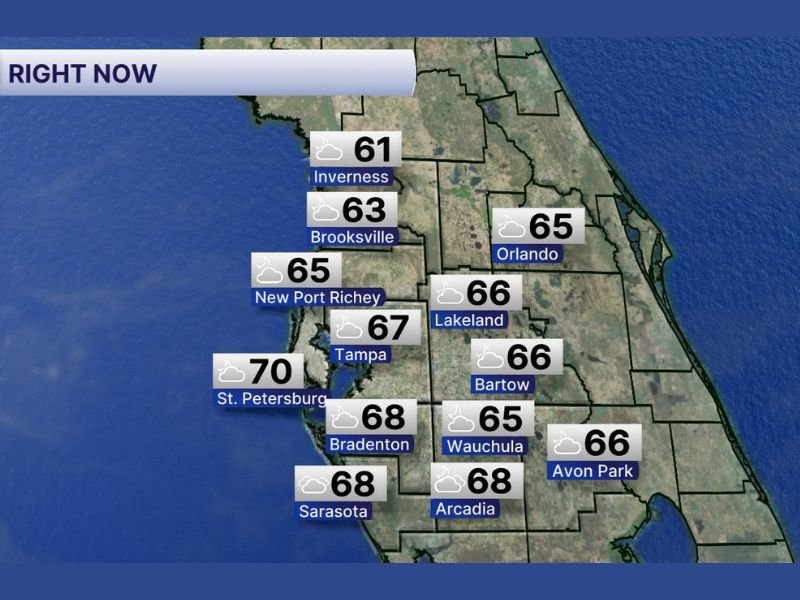
The latest readings show a consistent spread of mild temperatures across the region. Tampa is at 67 degrees, while nearby St. Petersburg is slightly warmer at 70 degrees, making it one of the warmest spots early on.
Further inland, temperatures remain steady:
- Lakeland and Bartow are both at 66 degrees
- Orlando is holding at 65 degrees
- Brooksville is slightly cooler at 63 degrees
- Inverness is the coolest at 61 degrees
Coastal and southern areas are also experiencing mild conditions, with Bradenton and Sarasota at 68 degrees, and Arcadia matching that at 68 degrees as well.
These readings reflect a stable and humid morning environment, which often acts as a precursor to later-day storm development in Florida.
Increasing Rain and Storm Chances by Afternoon
While the morning remains mostly quiet, weather conditions are expected to shift noticeably as the day progresses. Atmospheric moisture combined with daytime heating will likely trigger scattered showers and thunderstorms across the region.
Cities including Tampa, New Port Richey, Lakeland, Orlando, and Wauchula are all within the zone where rain chances will increase during the afternoon hours.
The setup suggests:
- Spotty showers developing first
- Storms becoming more widespread into the evening
- Brief downpours and lightning possible in stronger cells
This type of pattern is typical for Florida, where calm mornings can quickly transition into active weather later in the day.
Regional Impact and What Residents Should Expect
For residents across the Tampa Bay and central Florida region, the biggest impact will be timing. Outdoor plans during the afternoon and evening may be affected as storms develop unevenly across cities.
Drivers should remain alert for:
- Sudden heavy rain reducing visibility
- Wet road conditions during peak travel hours
- Lightning risks during stronger storms
Even though severe weather is not explicitly indicated, localized storms can still produce short bursts of intense rainfall.
Calm Start, Active Finish to the Day
The overall trend highlights a quiet and comfortable morning transitioning into a more unsettled afternoon and evening. With temperatures already in the 60s and 70s, conditions are primed for storm activity as the day heats up.
Weather patterns like this will continue to be monitored closely as showers and storms develop across Florida later today. Stay with NapervilleLocal.com for continued updates on changing weather conditions across the region.

I’ve lived in Naperville long enough to see how quickly our community changes — from new developments downtown to sudden shifts in our Midwest weather. Reporting on Naperville news and daily forecasts gives me the chance to keep neighbors informed about what really matters. My goal is simple: deliver clear, timely updates so you always know what’s happening in our city and what to expect from the skies above.