
Florida Temperatures to Dip Into the 30s and 50s Next Week as Cooler Air Returns Across the State
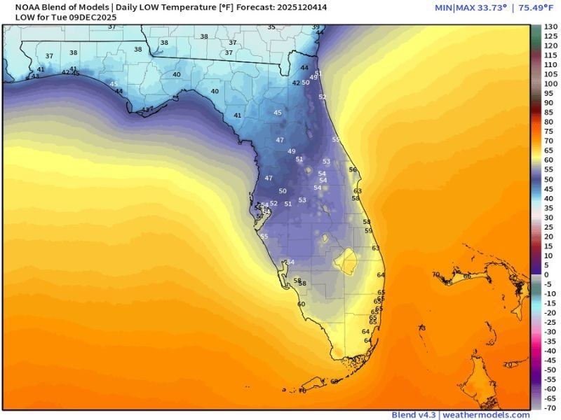
TALLAHASSEE, FLORIDA — Cooler weather is set to return to Florida early next week as a new surge of continental air moves southward, briefly lowering temperatures statewide. According to NOAA’s blended model forecast, lows on Tuesday, December 9, could fall into the 30s across northern Florida and the 50s as far south as Miami and the Keys.
While this pattern won’t rival Florida’s more extreme cold snaps from past winters, it will mark one of the state’s coolest nights so far this December — a noticeable shift for residents accustomed to mild holiday weather.
Statewide Chill from Panhandle to South Florida
Meteorologists with Spaghetti Models note that the cooler air will filter southward from the Southeast U.S., sending temperatures sharply downward by early Tuesday morning.
- North Florida (Pensacola, Tallahassee, Lake City): Lows could dip into the upper 30s to low 40s, with patchy frost possible in rural areas.
- Central Florida (Orlando, Tampa, Ocala): Temperatures will bottom out in the mid-40s to low 50s, producing crisp mornings and mild afternoons.
- South Florida (Fort Lauderdale, Miami, Naples): Expect lows in the upper 50s to mid-60s, making for comfortable, breezy conditions.
The chill is being driven by a brief north-northwest flow behind a weak cold front, which will usher in drier, cooler air from the continental interior.
Iguanas Likely Safe from This Round of Cold
One question Floridians often ask when cold air moves in: “Will the iguanas fall?” According to forecasters, this event should stay mild enough to avoid triggering the “falling iguana” phenomenon — which typically occurs when temperatures plunge below 40°F for an extended period.
The model data from weathermodels.com suggests that even in northern Florida, temperatures will stay just above that threshold, meaning reptiles and tropical wildlife should be unaffected this time around.
Quick Cool-Down, Then Rebound
The cool air will linger only for a short stretch. By Wednesday afternoon, highs across most of Florida will climb back into the upper 60s and 70s, marking a swift rebound typical of early winter patterns across the peninsula.
“It’s more of a refreshing cool-down than a freeze event,” meteorologist Mike Boylan explained. “We’ll get a couple of crisp mornings before warmer Gulf air pushes back by midweek.”
What to Expect
- Monday Night–Tuesday Morning: Temperatures drop sharply; coldest readings in the northern inland counties.
- Tuesday Afternoon: Clear skies and light breezes with highs in the upper 50s to mid-60s.
- Wednesday–Thursday: Gradual warm-up; highs rebound into the low 70s statewide.
Residents are encouraged to keep light jackets handy for the early morning hours but can expect a fast return to typical December warmth by midweek.
Stay updated on Florida’s changing weather patterns and local forecasts at NapervilleLocal.com.

I’ve lived in Naperville long enough to see how quickly our community changes — from new developments downtown to sudden shifts in our Midwest weather. Reporting on Naperville news and daily forecasts gives me the chance to keep neighbors informed about what really matters. My goal is simple: deliver clear, timely updates so you always know what’s happening in our city and what to expect from the skies above.