
Florida Temperatures to Plunge Up to 60 Degrees as Arctic Cold Front Sweeps the State
FLORIDA — The Sunshine State is about to experience a massive weather whiplash, with forecasters warning that temperatures could plunge up to 60 degrees between Sunday and Tuesday as an arctic cold front sweeps across the region.
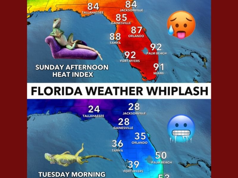
Meteorologists describe it as one of the sharpest temperature drops in Florida this fall, transforming the state’s late-season heat into a sudden winter chill. On Sunday, much of Florida will feel more like midsummer, with heat index values near 90°F. But by early Tuesday morning, parts of the state — including the Panhandle and North Florida — could see wind chills in the 20s and frosty conditions reaching as far south as Fort Myers and Palm Beach.
“Big drop in temperatures ahead across the state with it feeling 50–60 degrees colder between Sunday and Tuesday,” said meteorologist Matt Devitt of WINK Weather, who called the upcoming change “Florida weather whiplash.”
From Sweltering Heat to Freezing Cold in Just Two Days
The temperature swing will be extreme and rapid. On Sunday, Fort Myers and Palm Beach will reach around 92°F, while Orlando and Tampa will sit between 87–88°F. Miami is forecast to reach 91°F, and Tallahassee and Jacksonville will hover near 84–85°F.
By Tuesday morning, conditions will look drastically different:
- Tallahassee: Wind chill near 24°F
- Jacksonville & Gainesville: Around 28°F
- Orlando: 35°F
- Fort Myers: 39°F
- Palm Beach: 50°F, Miami: 53°F
The biggest temperature change will hit North Florida, where the difference between Sunday afternoon highs and Tuesday morning lows could exceed 55 to 60 degrees. Meteorologists say this kind of drop is rare in Florida but not impossible when strong arctic air masses push unusually far south.
Why the Sudden Temperature Crash?
The cause of this dramatic shift is a powerful arctic front sweeping down from the Midwest, pushing deep into the southeastern United States. As the cold front moves through Florida late Sunday night, it will sweep away humid air and replace it with a surge of dry, dense polar air, leading to a sudden and sharp temperature decline.
Cold fronts typically stall before reaching South Florida, but this system is strong enough to reach Miami, Palm Beach, and even the Florida Keys.
“It’s the kind of cold front that can make it feel like winter overnight,” said Devitt. “And yes, even the iguanas will be feeling it.”
“Falling Iguanas” Possible in South Florida
As temperatures dip below 40°F, South Floridians may see iguanas falling from trees — a unique occurrence that happens when the reptiles’ bodies become too cold to function. These cold-blooded animals depend on external warmth, and when the air drops too fast, they become temporarily paralyzed, often falling from branches.
Wildlife officials emphasize that these iguanas aren’t dead — most will revive once the sun returns. Residents are urged not to touch or move them, as they can react suddenly when warmed.
How Long Will the Cold Last?
The coldest period is expected from Monday night into Tuesday morning, when freezing or near-freezing conditions could stretch across North and Central Florida. Fortunately, the chill won’t last long.
By Wednesday, temperatures should rebound into the 60s and 70s, restoring Florida’s familiar warmth. Experts call this event a brief but intense “cold shock”, where the rapid flip from tropical heat to winter-like chill can stress both wildlife and residents.
How Residents Should Prepare
Meteorologists recommend taking precautionary steps before the front arrives:
- Protect pets, plants, and pipes, especially in northern and central regions.
- Dress in layers for chilly mornings on Monday and Tuesday.
- Check on elderly neighbors and those without proper heating.
- Avoid overwatering plants, which could freeze overnight.
The National Weather Service may issue frost advisories or freeze warnings for several inland counties as temperatures approach freezing early Tuesday.
Outlook for the Week Ahead
By midweek, sunshine and milder air will return. Highs on Wednesday and Thursday are forecast to reach the upper 60s to mid-70s, with low humidity and calmer winds — a quick rebound to typical fall weather for Florida.
“This is a classic Florida pattern,” Devitt said. “One day you’re at the beach, and two days later you’re reaching for a jacket.”
Residents are encouraged to stay alert for official weather alerts and monitor NapervilleLocal.com for more regional updates, temperature changes, and safety advisories.

I’ve lived in Naperville long enough to see how quickly our community changes — from new developments downtown to sudden shifts in our Midwest weather. Reporting on Naperville news and daily forecasts gives me the chance to keep neighbors informed about what really matters. My goal is simple: deliver clear, timely updates so you always know what’s happening in our city and what to expect from the skies above.