
Florida Warms Back Up Thursday Feb. 12 as “Spring in the Air” Forecast Shows 70s and Low 80s Statewide
FLORIDA — After another cold start, the forecast shown in the latest temperature graphic points to a fast warm-up returning across the state by Thursday, Feb. 12, with many communities climbing into the 70s and several areas pushing into the low 80s.
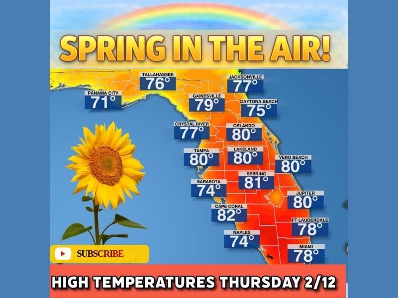
A Statewide Warm Pattern Returns After the Chill
The map is labeled “Spring in the Air!” and shows a broad warm zone covering most of Florida by Thursday afternoon. The warmest colors are centered across Central and South Florida, where multiple cities are shown reaching 80 degrees or higher.
This is the kind of setup that feels like classic Florida winter weather whiplash: jackets early, short sleeves later—especially with afternoon sunshine and a warmer air mass settling in.
City-by-City High Temperatures Shown for Thursday, Feb. 12
The forecast highs displayed on the map include:
- Panama City: 71°
- Tallahassee: 76°
- Jacksonville: 77°
- Gainesville: 79°
- Daytona Beach: 75°
- Crystal River: 77°
- Orlando: 80°
- Tampa: 80°
- Lakeland: 80°
- Vero Beach: 80°
- Sarasota: 74°
- Sebring: 81°
- Cape Coral: 82°
- Naples: 74°
- Jupiter: 80°
- Fort Lauderdale: 78°
- Miami: 78°
Where the Warmest Air Is Concentrated
From the distribution of temperatures on the map, the strongest warmth is focused through Central Florida down into South Florida, where 80s are most common (Orlando, Tampa, Lakeland, Vero Beach, Jupiter) and where Cape Coral (82°) stands out as one of the hottest readings shown.
North Florida still warms up noticeably, but highs trend a bit cooler closer to the Panhandle and far northern areas—like Panama City (71°) and Tallahassee (76°)—which still represent a comfortable February rebound compared to the colder mornings.
What Floridians Should Keep in Mind
Even with warm afternoons, it’s still smart to plan for a big day-to-day and morning-to-afternoon swing.
Light layers can help if you’re heading out early, and if you’ll be outside during peak afternoon warmth—especially in the interior—water and sun protection can make a difference since temperatures are forecast to sit near 80° for many communities.
What You’re Seeing Where You Live
Are you still waking up to a chilly start, or are you already feeling the warm-up? Tell us what your morning feels like and what your afternoon high hits—then join the conversation at NapervilleLocal.com.

I’ve lived in Naperville long enough to see how quickly our community changes — from new developments downtown to sudden shifts in our Midwest weather. Reporting on Naperville news and daily forecasts gives me the chance to keep neighbors informed about what really matters. My goal is simple: deliver clear, timely updates so you always know what’s happening in our city and what to expect from the skies above.