
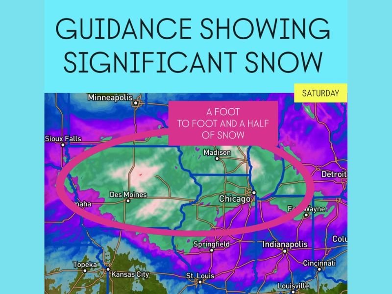
Forecast Models Show a Foot to a Foot and a Half of Snow Possible Between Des Moines, Chicago, and Madison on Saturday
CHICAGO, ILLINOIS — Weather models are showing growing confidence in a significant snowfall event expected to impact the upper Midwest and western Great Lakes this weekend. Forecast guidance indicates a foot to a foot and a half of snow could fall between Des Moines, Chicago, and Madison on Saturday, raising concerns about hazardous travel and potential disruptions.
High-resolution data points to a concentrated corridor of heavy snow forming across this stretch, where colder air and sufficient moisture will overlap to produce sustained, intense snowfall rates.
Forecast Overview
Meteorologists describe the current model runs as “bullish,” signaling that the system is likely to deliver widespread heavy snow through Saturday. The heaviest accumulation is expected within the central corridor highlighted on current maps — covering portions of eastern Iowa, northern Illinois, and southern Wisconsin.
“Guidance is showing a foot to a foot and a half of snow for these areas,” weather analysts said, adding that even small forecast adjustments could influence where the most snow falls.
Areas Expected to Be Most Affected
The snow band appears to stretch from Des Moines, Iowa, through northern and central Illinois, and into southern Wisconsin, particularly near Madison.
Major population centers, including the Chicago metropolitan area, are projected to see some of the most intense snowfall rates during the day on Saturday.
Travel and Safety Concerns
Meteorologists are urging caution for anyone traveling within the region. Heavy snow and strong winds could create low visibility, slick roads, and potential delays across major interstates and airports.
Travel through Des Moines, Rockford, Chicago, and Madison could be difficult, with several hours of steady accumulation expected. Airlines operating at Chicago O’Hare and Midway airports may experience schedule changes or cancellations if snowfall rates increase as predicted.
Timing and Outlook
Snow is expected to begin early Saturday morning, intensify through midday, and taper off by Saturday night as the system moves east. However, frigid air is likely to settle in behind the storm, leading to freezing conditions through Sunday morning.
Residents across the Midwest are advised to keep monitoring official National Weather Service updates for any winter storm watches or warnings as confidence continues to build.
Stay with NapervilleLocal.com for ongoing coverage, storm tracking, and travel safety updates as this weekend’s snow system approaches.

I’ve lived in Naperville long enough to see how quickly our community changes — from new developments downtown to sudden shifts in our Midwest weather. Reporting on Naperville news and daily forecasts gives me the chance to keep neighbors informed about what really matters. My goal is simple: deliver clear, timely updates so you always know what’s happening in our city and what to expect from the skies above.