
Freezing Fog Threat Looms Over North and Central Texas as Reinforced Cold Front Arrives Wednesday Morning
TEXAS — A renewed winter weather concern is taking shape across North and Central Texas, where updated short-range forecast data shows a high potential for freezing fog early Wednesday morning, following melting conditions Tuesday afternoon and the arrival of a reinforced cold front overnight.
Temperatures are expected to fall back into the 20s across much of the region, creating conditions favorable for fog formation that could freeze on contact, adding a fresh layer of ice to roads that are already slick from earlier winter weather.
Reinforced Cold Front Sets the Stage Overnight
Forecast data indicates that warmer air and melting during Tuesday afternoon will be quickly replaced by colder air pushing south into Texas by early Wednesday. This rapid temperature drop increases the risk of surface moisture refreezing, particularly in low-lying and poorly drained areas.
The cold front is expected to arrive before sunrise, locking in subfreezing temperatures during the Wednesday morning commute window.
Freezing Fog May Create Sudden Visibility and Ice Hazards
The greatest concern is the development of freezing fog, which can be especially dangerous because it:
- Reduces visibility suddenly
- Deposits ice on roads, bridges, and overpasses
- Creates black ice that is difficult to detect
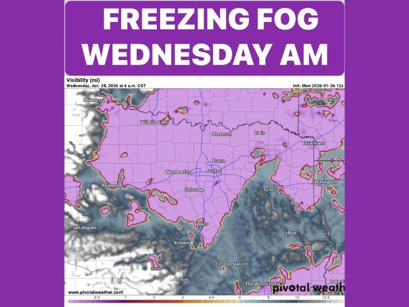
Forecast visibility maps show widespread areas across Dallas–Fort Worth, Waco, Wichita Falls, Sherman, Paris, and surrounding communities falling into fog-prone conditions during the early morning hours.
Already Slick Roads Could Become More Dangerous
With some roadways still damp from melting ice and snow, freezing fog could add a new glaze of ice on top of existing slick surfaces. This raises the risk of:
- Spin-outs and multi-vehicle crashes
- Hazardous bridge crossings
- Dangerous early-morning travel conditions
Drivers may encounter icy patches even if precipitation is no longer falling.
Improvement Expected by Wednesday Afternoon
As daytime heating resumes, temperatures are forecast to climb back above freezing Wednesday afternoon, allowing fog to gradually burn off. Skies are expected to turn partly cloudy, improving visibility and travel conditions later in the day.
However, officials caution that early morning travel remains the most dangerous period, especially before sunrise.
Travel Caution Urged for Wednesday Morning
Motorists across North and Central Texas are urged to:
- Slow down during foggy conditions
- Avoid sudden braking
- Use low-beam headlights
- Be especially cautious on bridges and overpasses
Even short commutes could become hazardous if freezing fog develops as projected. For continued coverage of major weather threats, road hazards, and developing conditions across the U.S., stay with NapervilleLocal.com and share what you’re seeing in your area.

I’ve lived in Naperville long enough to see how quickly our community changes — from new developments downtown to sudden shifts in our Midwest weather. Reporting on Naperville news and daily forecasts gives me the chance to keep neighbors informed about what really matters. My goal is simple: deliver clear, timely updates so you always know what’s happening in our city and what to expect from the skies above.