
Georgia and Southeast Face Rare Collision of Ice Storm Warnings and Tornado Threat as Massive Winter System Pushes East
UNITED STATES — A highly unusual and dangerous winter storm system is unfolding across the Southeastern United States, bringing together tornado watches, ice storm warnings, winter storm warnings, and intense thunderstorms at the same time — a setup meteorologists say is extremely rare for this region.
The storm is being described as one of the most dynamically complex systems to impact the Southeast since the 1993 “Storm of the Century,” with impacts stretching from Mississippi and Alabama through Georgia and into the Carolinas as the system continues to move east.
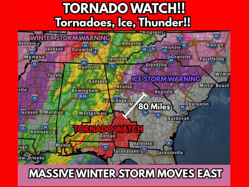
Tornado Watch Issued Across Southern Alabama and Southwest Georgia
A Tornado Watch is in effect across southern Alabama and southwest Georgia, including areas near Dothan, Montgomery, and Tallahassee, where strong thunderstorms are developing along a fast-moving cold front.
Forecasters warn these storms may produce damaging wind gusts, embedded tornadoes, and heavy rainfall, even as colder air rapidly advances behind the system. The unusual aspect of this setup is that tornado activity is occurring alongside winter weather hazards, a combination rarely seen at this scale in the Deep South.
Ice Storm Warnings Blanket Central and Eastern Georgia
Large portions of central and eastern Georgia, including areas near Atlanta, Augusta, and toward the South Carolina border, are under Ice Storm Warnings, with freezing rain expected to be the dominant precipitation type.
Forecasters warn that significant ice accumulation could occur, leading to:
• Widespread power outages
• Downed trees and power lines
• Extremely hazardous travel conditions
Officials emphasize that freezing rain is more dangerous than snow, as even small ice accumulations can cripple infrastructure.
Winter Storm Warnings Extend North Into Tennessee and Mississippi
Farther north, Winter Storm Warnings stretch across parts of Tennessee and northern Mississippi, including areas near Memphis, Jackson, and portions of central Tennessee. These regions are expected to see a mix of snow, sleet, and freezing rain, with rapidly falling temperatures making road conditions deteriorate quickly overnight.
Storm System Spans Over 80 Miles of Clashing Weather Types
Meteorologists note that within a span of roughly 80 miles, conditions shift dramatically from severe thunderstorms and tornado threats to crippling ice storms, highlighting just how volatile and complex this system is.
The clash between warm, unstable air and rapidly advancing Arctic air is fueling the storm’s intensity and creating multiple life-threatening hazards simultaneously.
Impacts Expected to Linger Into Next Week
Officials warn that this is not a short-lived event. Even after the storm moves east, cold air is expected to remain locked in, allowing impacts such as power outages, icy roads, and infrastructure damage to persist into next week.
Emergency managers across multiple states are urging residents to avoid unnecessary travel, prepare for extended power disruptions, and closely monitor local alerts as conditions evolve rapidly. This storm is still unfolding, and additional warnings and advisories are likely as it continues eastward.
What are you seeing in your area as this historic winter system moves through? Share your experience and stay informed with continued coverage at NapervilleLocal.com.

I’ve lived in Naperville long enough to see how quickly our community changes — from new developments downtown to sudden shifts in our Midwest weather. Reporting on Naperville news and daily forecasts gives me the chance to keep neighbors informed about what really matters. My goal is simple: deliver clear, timely updates so you always know what’s happening in our city and what to expect from the skies above.