
Georgia and the Carolinas Could See Light Snow Risk Around January 15 as 7-Day GFS Model Signals Winter Pattern Shift
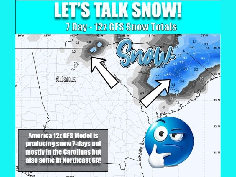
GEORGIA — Forecast models are beginning to hint at a possible winter weather setup around Thursday, January 15, though meteorologists stress that confidence remains low due to the system being 7 days out. The latest 12z GFS model run shows snow developing mainly across the Carolinas, with northeast Georgia on the western edge of the colder air, raising the possibility of light snow or flurries.
Forecasters caution that anything 5–7 days out is considered low probability, and the setup should be viewed as an early signal of a changing weather pattern rather than a locked-in forecast.
Snow Focused in the Carolinas, Northeast Georgia on the Fringe
According to the current model depiction, the primary winter storm signal is concentrated in the Carolinas, where colder air and coastal development appear more favorable for accumulating snow. In northeast Georgia, the region is not directly in the core of the storm system but could be affected by colder air pressing southward, potentially squeezing out light snow or flurries. At this stage, any snow in Georgia would likely be minor and highly localized, if it occurs at all.
Cold Air Push and Gulf Energy Driving the Setup
The model scenario shows energy diving south into the Gulf, with a coastal low forming along the Southeast coast. This configuration favors winter weather mainly east of Georgia, while colder air filtering in from the north could briefly impact higher elevations in far northeast Georgia.
Meteorologists emphasize that this setup is evolving rapidly and will likely change as newer model runs come in, particularly European guidance expected later.
Pattern Shift Matters More Than Snow Totals Right Now
While snow totals remain uncertain, the bigger takeaway is the clear signal of a colder, more active winter pattern developing across the Southeast. This aligns with broader mid-January trends showing increased cold air availability, even if individual storm tracks remain unclear.
Residents are encouraged to treat this as a “something to watch” scenario, not a forecast guarantee. More updates will follow as confidence improves and model agreement increases. For continued coverage of national and regional weather pattern shifts explained clearly and without hype, visit NapervilleLocal.com.

I’ve lived in Naperville long enough to see how quickly our community changes — from new developments downtown to sudden shifts in our Midwest weather. Reporting on Naperville news and daily forecasts gives me the chance to keep neighbors informed about what really matters. My goal is simple: deliver clear, timely updates so you always know what’s happening in our city and what to expect from the skies above.