
Georgia, Florida, Alabama, and the Carolinas Brace for Thursday Storm Line Bringing Widespread Rain and Possible Thunderstorms
UNITED STATES – A developing weather system is expected to sweep across Georgia, Florida, Alabama, South Carolina, and North Carolina on Thursday, bringing steady rain, scattered thunderstorms, and pockets of heavier downpours by late afternoon into the evening hours.
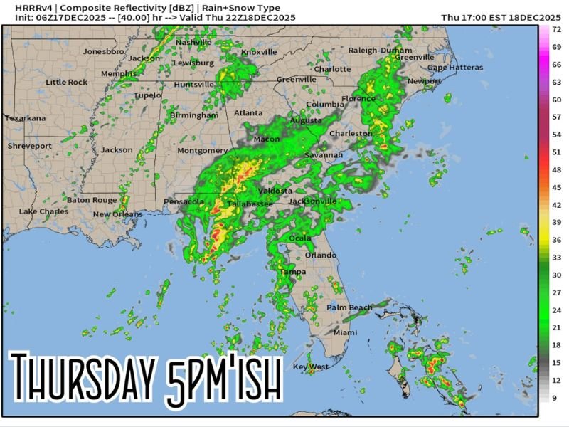
Future Radar Shows Strongest Activity Near 5 PM Thursday
According to high-resolution future radar guidance, a well-defined line of rain and storms will stretch from the Gulf Coast through the Southeast by around 5 PM EST on Thursday.
Areas from Tallahassee to Valdosta, Macon, Augusta, Columbia, and Charleston are likely to see the most concentrated rainfall.
Forecasters note that while this is not expected to be a severe outbreak, some communities could still experience brief thunderstorms, gusty winds, and heavy bursts of rainfall as the front pushes through.
Storm Line Moves Overnight Into the Coastal Carolinas
By late Thursday night, the system is projected to continue eastward, bringing rain and occasional storms to coastal regions such as Wilmington, Myrtle Beach, and Charleston.
Light to moderate rain will also extend northward into parts of North Carolina, including the Raleigh and Greenville areas. Meteorologists say the system should clear the region by early Friday, leaving behind cooler, drier air.
As this shifting storm line impacts several southeastern states, NapervilleLocal.com will continue providing clear and timely weather updates to help readers stay informed wherever developing systems may affect travel or safety.

I’ve lived in Naperville long enough to see how quickly our community changes — from new developments downtown to sudden shifts in our Midwest weather. Reporting on Naperville news and daily forecasts gives me the chance to keep neighbors informed about what really matters. My goal is simple: deliver clear, timely updates so you always know what’s happening in our city and what to expect from the skies above.