
Georgia Severe Storm Threat Builds This Afternoon as Supercells Target Atlanta-to-Augusta Corridor With 50–70 MPH Wind Risk
GEORGIA — Strong to severe thunderstorms may ramp up this afternoon across parts of central Georgia, with the highest concern focused along and south of a stationary front. Based on the latest guidance and radar trends, supercells are considered likely in the most favorable corridor, and the primary threat may be damaging straight-line winds capable of producing localized gusts in the 50 to 70 mph range.
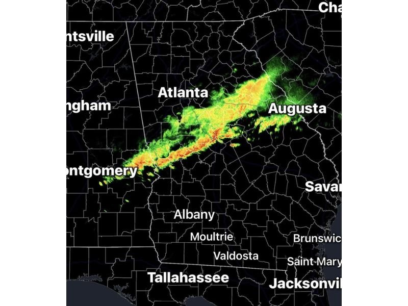
A noon radar snapshot shows a developing band of storms extending from near the Alabama line toward the Atlanta metro and east toward the Augusta area, signaling that storms are already organizing along the boundary. As heating continues into the afternoon, storms in and near this band could intensify quickly, especially where individual cells can rotate and become discrete supercells.
When Strongest Storms Are Most Likely
The main window for stronger storms appears to be between noon and 6 PM, when daytime heating and the stationary front combine to increase instability and lift. Forecasters note that the environment along and south of the boundary may support rotating updrafts, which is why supercells are on the table rather than only a line of general thunderstorms.
If storms remain more clustered, the biggest impacts could come in bursts as stronger segments move through. If storms can break into isolated or semi-isolated cells, the risk for brief rotation and localized higher-end wind gusts can increase.
Primary Threat: Damaging Winds Up to 70 MPH
Damaging winds are considered the greatest threat with the strongest storms today. Gusts in the 50–70 mph range can down tree limbs, topple weaker trees, and cause spotty power outages, particularly where soils are saturated or where winds hit in repeated bursts.
Travel may also be affected, especially on highways near heavier downpours where visibility drops rapidly and debris can end up on roadways.
Hail Risk Lower, But Still Possible
While hail is not expected to be the dominant hazard, hail is still possible with the stronger storms, with the most likely size range described as penny to quarter size. Even smaller hail can create hazardous driving conditions, especially when combined with heavy rain and gusty winds.
Brief Tornado Spin-Up Can’t Be Ruled Out
A brief tornado is also possible, especially with any storm that becomes a supercell or interacts strongly with the stationary front. These setups can sometimes produce quick, short-lived spin-ups that develop with limited warning time.
Because of the wind and rotation potential, forecasters note the Storm Prediction Center may need to consider issuing a Severe Thunderstorm Watch or Tornado Watch for parts of central Georgia later today.
What To Do If Warnings Are Issued
If warnings are posted in your area this afternoon, move indoors, avoid windows, and be prepared to take shelter quickly if a tornado warning is issued. Keep phones charged and have multiple ways to receive alerts through the late afternoon and early evening.

I’ve lived in Naperville long enough to see how quickly our community changes — from new developments downtown to sudden shifts in our Midwest weather. Reporting on Naperville news and daily forecasts gives me the chance to keep neighbors informed about what really matters. My goal is simple: deliver clear, timely updates so you always know what’s happening in our city and what to expect from the skies above.