
Georgia, South Carolina, and North Carolina Face Unusually Cold Snow Setup as Temperatures Drop Into Teens and Low 20s Saturday
SOUTHEASTERN UNITED STATES — A developing winter system is drawing attention across Georgia, South Carolina, North Carolina, and parts of Alabama and Tennessee, where Saturday’s snow event is shaping up to be unusually cold, a factor that could significantly increase snowfall efficiency and accumulation rates across the region.
Meteorologists monitoring the setup say temperatures during the height of the snow will be far colder than what is typically seen with Southern snow events, raising concerns for faster accumulation even where overall moisture amounts are modest.
Why This Snow Setup Is Different
Forecast data shows surface temperatures falling into the teens and low 20s across parts of the southern Appalachians and interior Southeast during the snow. In central and southern sections of the region, temperatures are expected to hover in the low to mid-20s while snow is actively falling.
This matters because colder air allows snowflakes to remain drier and fluffier, which increases how efficiently snow piles up on the ground.
Under normal Southern winter storms, snow-to-liquid ratios average around 8:1, meaning one inch of liquid precipitation produces about eight inches of snow. In this colder setup, ratios could climb closer to 12:1 or even 15:1, allowing snow to accumulate faster than many residents are used to seeing.
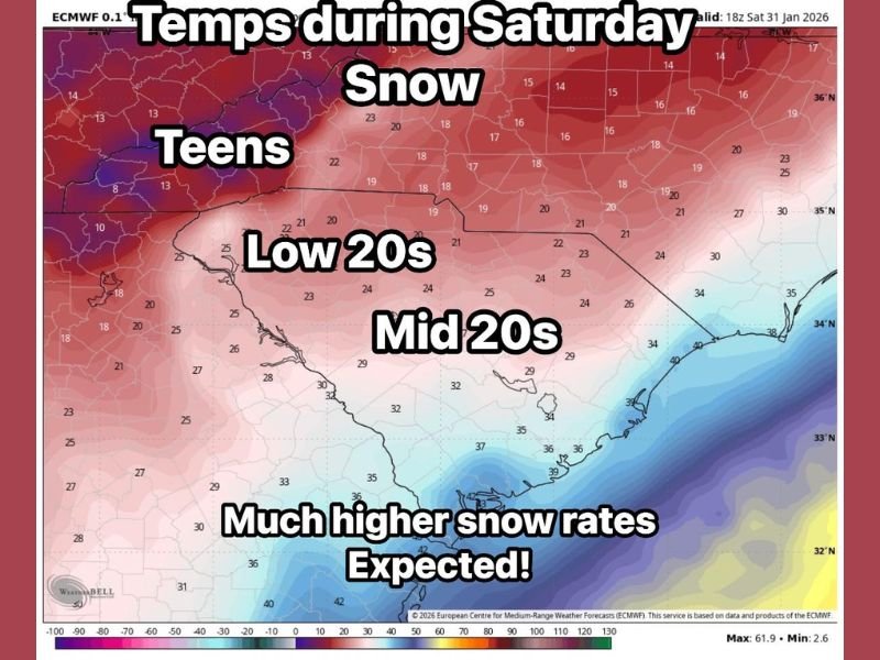
Expected Temperature Breakdown During Snow
- Teens: Higher elevations and northern sections, including parts of western North Carolina and eastern Tennessee
- Low 20s: Interior areas of Georgia and South Carolina
- Mid 20s: Southern and eastern sections closer to the coastal plain
These temperatures are cold enough to support higher snowfall rates, especially during heavier bursts.
What This Means for Accumulation
Even short-lived or moderate snowfall could quickly cover roads, bridges, and untreated surfaces. Colder ground temperatures also reduce melting, increasing the risk of slick travel conditions developing rapidly once snow begins.
Forecasters caution that snow totals could outperform initial expectations if these colder temperatures verify, especially during peak snowfall periods Saturday.
Forecast Still Being Refined
Weather models are still processing new data, and meteorologists say details regarding exact snowfall amounts and placement will become clearer as the event gets closer. Small shifts in temperature or storm track could make a noticeable difference in who sees the highest impacts.
Residents across Georgia, South Carolina, North Carolina, and neighboring states are encouraged to stay alert for forecast updates, particularly if travel plans are scheduled for Saturday.
For continued updates and clear breakdowns of significant weather events impacting communities across the country, follow ongoing coverage from NapervilleLocal.com.

I’ve lived in Naperville long enough to see how quickly our community changes — from new developments downtown to sudden shifts in our Midwest weather. Reporting on Naperville news and daily forecasts gives me the chance to keep neighbors informed about what really matters. My goal is simple: deliver clear, timely updates so you always know what’s happening in our city and what to expect from the skies above.