
Georgia Winter Storm Watch Expands West as Snow, Strong Winds, and Dangerous Cold Target North and East-Central Counties
Georgia — A widening Winter Storm Watch is now in effect across portions of north, northeast, and east-central Georgia as forecasters warn of accumulating snow, strong wind gusts, and dangerous cold conditions developing from Friday evening through Sunday morning.
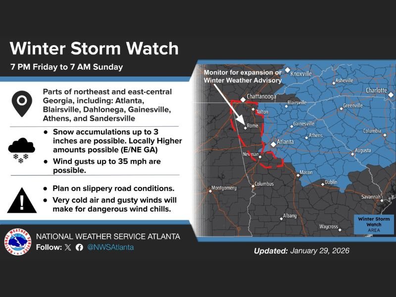
According to updated guidance from the National Weather Service, the storm system is expected to bring snowfall totals between 2 and 4 inches, with locally higher amounts possible, particularly in elevated and northern areas. Gusty winds reaching up to 35 miles per hour could further worsen travel conditions and increase the risk of dangerously low wind chills.
Areas Included in the Winter Storm Watch
The Winter Storm Watch covers parts of northeast and east-central Georgia, including major population centers and surrounding communities such as Atlanta, Blairsville, Dahlonega, Gainesville, Athens, and Sandersville.
Forecasters note that the watch area has expanded westward, signaling growing confidence that winter weather impacts will affect a broader portion of the state than initially anticipated. Residents within these regions are urged to closely monitor forecast updates as the storm approaches.
Snowfall and Wind Expectations
Forecast models indicate snow accumulations of up to 3 inches are likely, with isolated locations possibly exceeding that amount, especially across northeast Georgia. The combination of snow and gusty winds may lead to reduced visibility at times, particularly during heavier snow bursts.
Wind gusts as high as 35 mph could cause blowing snow in open areas and increase the potential for scattered power disruptions, especially where snow becomes wet and heavy.
Travel and Infrastructure Impacts
Road conditions are expected to deteriorate rapidly once snow begins, with bridges and overpasses becoming slick and hazardous first. Officials warn that even minor accumulations can lead to significant travel issues across Georgia, where winter weather infrastructure is limited.
Drivers are advised to plan for slippery roads, reduced travel speeds, and possible delays, particularly during overnight and early morning hours when temperatures are coldest.
Dangerous Cold and Wind Chill Concerns
Behind the snowfall, a surge of Arctic air will drive dangerously low wind chills across the watch area. On Saturday, wind chill values are expected to range from 5 degrees below zero to the lower teens above zero.
By early Sunday, wind chills could drop further, ranging from 10 degrees below zero to the single digits above zero, increasing the risk of frostbite for anyone exposed to the elements for extended periods.
What Residents Should Do Now
Emergency officials recommend residents prepare ahead of the storm by limiting unnecessary travel, charging electronic devices, checking heating systems, and ensuring access to food and essential supplies through the weekend.
Those living in higher elevations or rural areas should be especially cautious, as snowfall totals and road impacts may be more severe in those locations.
As the winter storm approaches, additional advisories or warnings may be issued if confidence increases. NapervilleLocal.com will continue monitoring this developing winter system and its broader regional impacts, including potential travel disruptions that could extend beyond Georgia.

I’ve lived in Naperville long enough to see how quickly our community changes — from new developments downtown to sudden shifts in our Midwest weather. Reporting on Naperville news and daily forecasts gives me the chance to keep neighbors informed about what really matters. My goal is simple: deliver clear, timely updates so you always know what’s happening in our city and what to expect from the skies above.