
Great Lakes Bracing for Monster Waves Up to 34 Feet Monday as Storm System Generates Dangerous Marine Conditions
GREAT LAKES REGION — A powerful storm system is expected to produce massive waves across all five Great Lakes on Monday, with forecasters calling for some of the highest wave heights in decades. The National Weather Service warns that conditions may rival — and even exceed — past historic events on Lake Superior.
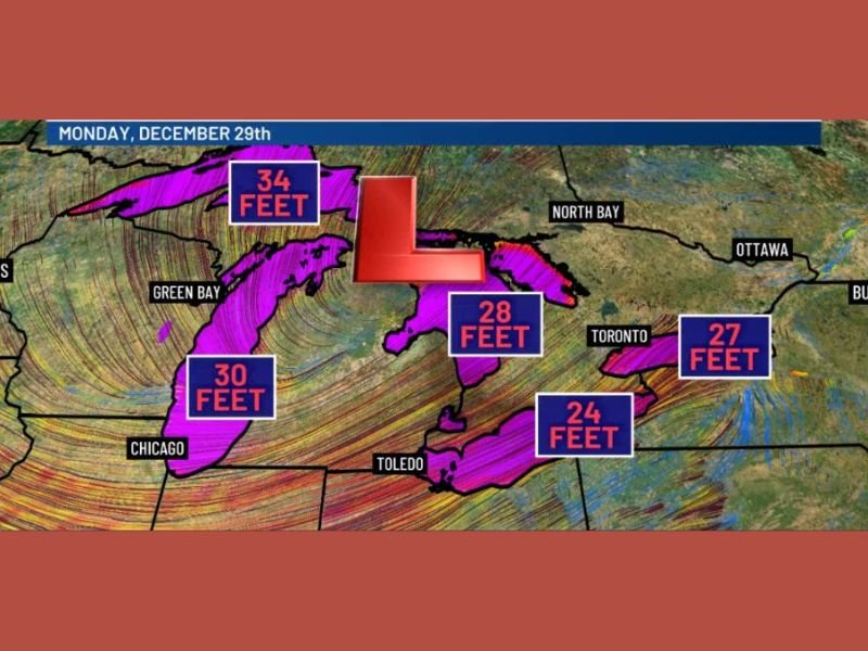
Waves Projected to Exceed 20 Feet on All Five Lakes
The latest marine forecasts show widespread, dangerous wave heights building early Monday as strong winds sweep across the region. All five Great Lakes are expected to see waves topping the 20-foot mark, creating treacherous conditions for mariners and coastal communities.
Top forecast wave heights:
- 34 feet on Lake Superior
- 30 feet on Lake Michigan
- 28 feet on Lake Huron
- 27 feet on Lake Ontario
- 24 feet on Lake Erie
Forecasters caution that the Lake Erie forecast may be conservative, as overnight model trends show increasing potential for even stronger wave development.
Lake Superior Facing Waves Larger Than Historic Shipwreck Event
Meteorologists note that Lake Superior’s projected 34-foot waves exceed those observed in the storm that sank the Edmund Fitzgerald more than 50 years ago. While ship design and forecasting tools have improved dramatically since then, waves of this size remain extremely dangerous.
These towering waves will combine with intense winds to create extremely hazardous boating and shipping conditions, as well as risks for those near the shoreline.
Severe Freezing Spray Likely Across Much of the Region
Along with the towering waves, severe freezing spray is expected on several of the Great Lakes. This can rapidly coat vessels, piers, and infrastructure in thick layers of ice, making rescue operations and navigation even more dangerous. Cold temperatures will accelerate ice accumulation, creating slippery surfaces and reducing visibility near the water.
Coastal Communities Urged to Take Safety Precautions
Authorities are warning residents to avoid shoreline observation points, as waves of this magnitude can easily sweep over barriers, piers, and coastal roads. Even casual storm watching can become life-threatening when waves exceed 20–30 feet. Those planning to photograph or observe the storm should maintain significant distance from the waterline, particularly along exposed sections of Lake Superior and Lake Michigan.
Safety reminders:
- Stay far back from piers and breakwalls
- Avoid low-lying coastal roads during peak waves
- Expect freezing spray and hazardous shore ice
- Follow all marine warnings issued by the NWS
Monitoring Continues as Monday Approaches
Marine forecasters will continue tracking the storm system as it strengthens, adjusting wave height expectations as needed. All indicators suggest that Monday will bring some of the most dangerous marine conditions seen on the Great Lakes in recent years.
Stay with NapervilleLocal.com for ongoing updates, new forecasts, and marine advisories as this powerful wave event approaches the Great Lakes region.

I’ve lived in Naperville long enough to see how quickly our community changes — from new developments downtown to sudden shifts in our Midwest weather. Reporting on Naperville news and daily forecasts gives me the chance to keep neighbors informed about what really matters. My goal is simple: deliver clear, timely updates so you always know what’s happening in our city and what to expect from the skies above.