
Great Lakes Prepare for Powerful Bomb Cyclone With 55–70 MPH Wind Gusts, 26–28 mb Pressure Drop, and 20+ Foot Waves Expected
OHIO — A rapidly intensifying storm system is expected to move into the Great Lakes late Sunday into Monday, with new overnight models showing the potential development of a rare bomb cyclone. Forecasters say this could become the strongest system to impact the region since the major pre-Christmas storm three years ago.
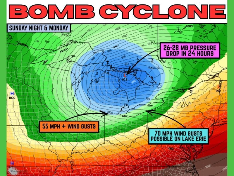
Storm Strengthening Rapidly as It Approaches the Great Lakes
Meteorologists are closely monitoring pressure changes that indicate explosive development. A bomb cyclone occurs when pressure drops rapidly — and in this case, models show a steep fall that could significantly increase wind speeds across the region.
Key storm figures:
- 26–28 mb pressure drop in 24 hours
- 55 mph+ wind gusts possible Monday
- 70 mph wind gusts possible on Lake Erie
- 20+ foot waves on all five Great Lakes
Wind Becomes the Main Threat for Many Areas
While northwestern Ohio is not expected to see severe storms or heavy snow, winds will be the primary impact. Forecasters warn that widespread strong gusts could create hazardous conditions across the region throughout Monday.
Winds may reach near hurricane-force levels over portions of Lake Erie, significantly increasing risks for boaters, shoreline communities, and infrastructure near the lake.
Major Waves and Seiche Threat Across the Great Lakes
A storm of this intensity will generate extremely large waves across all five Great Lakes. Waves reaching over 20 feet may cause flooding in low-lying shoreline areas and lead to rapid water level oscillations known as seiches.
A seiche on Lake Erie is considered likely, given the storm’s orientation and projected wind field. These events can cause sudden water level rises and drops that threaten marinas, docks, and coastal roads.
Watches and Warnings Expected Soon
Weather officials say a Wind Advisory is likely, with the possibility of a High Wind Warning if forecast gusts continue trending upward. These alerts would cover communities across northern Ohio and the western Great Lakes region. Power outages, fallen trees, and hazardous driving conditions are all possible as winds increase Sunday night into Monday.
Residents Urged to Prepare Before Conditions Worsen
Authorities recommend securing anything outside that could become airborne in strong winds. Trash bins, patio furniture, decorations, and construction materials may pose risks if not anchored properly. Drivers — especially those traveling near the lakes — should be prepared for difficult handling and sudden gusts.
Safety notes:
- Secure loose outdoor items before winds ramp up
- Avoid shoreline travel during peak wave activity
- Expect hazards Monday from blowing debris, falling limbs, and power flickers
More Updates Expected as the System Intensifies
Forecasters will continue monitoring the storm as it moves into the region. If pressure drops further or wind projections increase, additional warnings may be issued. Monday is shaping up to be a high-impact weather day across multiple Great Lakes states. Stay with NapervilleLocal.com for the latest updates and real-time coverage as the Great Lakes bomb cyclone develops.

I’ve lived in Naperville long enough to see how quickly our community changes — from new developments downtown to sudden shifts in our Midwest weather. Reporting on Naperville news and daily forecasts gives me the chance to keep neighbors informed about what really matters. My goal is simple: deliver clear, timely updates so you always know what’s happening in our city and what to expect from the skies above.