
Heavy Rain Bands Target Coastal South Carolina Sunday Evening as Downpours Bring Up to One Inch From Florence to Myrtle Beach
Florence, South Carolina — After a quiet and dry start to Sunday morning, a round of much-needed rainfall is expected to settle into coastal and northeastern South Carolina later today, with heavier downpours developing by late afternoon and evening. Rain totals are projected to reach one-half to one inch for most communities, offering beneficial moisture but also the potential for brief ponding in heavier bursts.
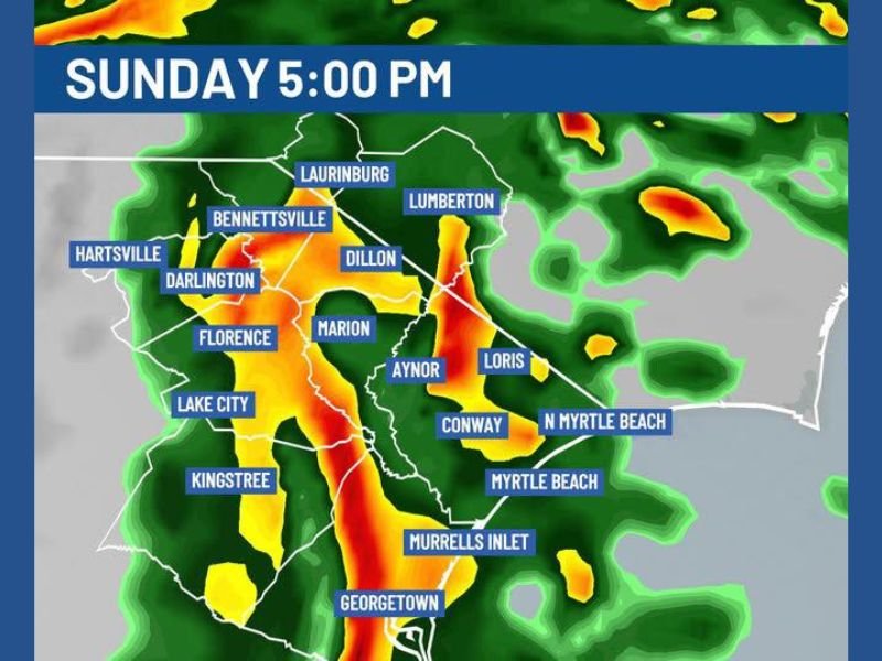
Forecast guidance shows showers increasing steadily through the afternoon, with more organized rain bands forming around 5:00 p.m. The most intense rainfall is expected to track from inland areas toward the coast, affecting communities across the Pee Dee and Grand Strand regions.
Heavier Downpours Develop Late Afternoon
By early evening, a concentrated band of rain is projected to move through Florence, Marion, and Georgetown, extending northward through Dillon, Bennettsville, and Darlington. Radar projections indicate pockets of moderate to heavy rainfall embedded within broader steady showers.
Further east, coastal communities including Myrtle Beach, North Myrtle Beach, Murrells Inlet, and Conway are likely to see periods of heavier rain as the system advances toward the Atlantic coastline. Areas such as Aynor and Loris may also experience stronger downpours as the rain band shifts eastward. While the rainfall is not expected to produce severe weather, brief heavy bursts could reduce visibility and create slick roadways during the late afternoon and evening hours.
Totals Expected Between One-Half and One Inch
Rainfall totals across much of northeastern South Carolina are forecast to range from 0.5 to 1 inch, with locally higher amounts possible under heavier downpours. Communities such as Lake City, Kingstree, and Laurinburg are expected to remain within the steady rain zone for several hours.
The rainfall will be especially beneficial given recent dry conditions in some areas, helping replenish soil moisture and support local waterways. However, localized ponding in low-lying spots cannot be ruled out where rainfall rates briefly intensify. Conditions are expected to gradually improve overnight as the rain band pushes offshore. Monday morning should begin with lingering clouds but diminishing precipitation.
This pattern reflects a typical late-winter system bringing widespread rain without significant severe weather risk, yet still delivering meaningful totals. For continued coverage of regional and national weather developments, visit NapervilleLocal.com for detailed updates and in-depth reporting.

I’ve lived in Naperville long enough to see how quickly our community changes — from new developments downtown to sudden shifts in our Midwest weather. Reporting on Naperville news and daily forecasts gives me the chance to keep neighbors informed about what really matters. My goal is simple: deliver clear, timely updates so you always know what’s happening in our city and what to expect from the skies above.