
Heavy Rainfall Expected Across the Deep South: Alabama, Mississippi, and Louisiana Could See Up to 5 Inches by Mid-December
BIRMINGHAM, ALABAMA — The Deep South is preparing for a multi-day soaking as new NOAA and WeatherModels projections indicate several inches of rain across Alabama, Mississippi, and Louisiana through Thursday, December 11. Some areas could see up to 5 inches of total rainfall, sparking early concerns about localized flooding and saturated ground conditions heading into the weekend.
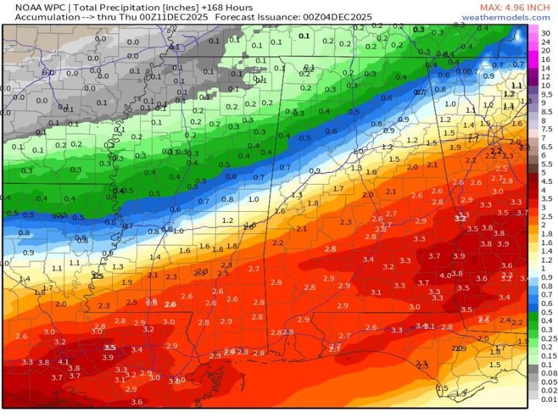
According to the NOAA Weather Prediction Center (WPC), a strong frontal boundary is expected to stall across the southern United States, funneling Gulf moisture northward and producing persistent, heavy rain bands. The heaviest precipitation will fall over a wide swath from eastern Texas through southern Arkansas and northern Louisiana, extending into central and southern Alabama and northwest Georgia.
Highest Rainfall Totals Centered Over the Deep South
The latest accumulation map shows a clear concentration of dark red and crimson zones, representing rainfall totals exceeding 4 inches across large portions of southern Mississippi, southern Alabama, and southeast Louisiana.
- Southern Alabama (Montgomery, Dothan, and Mobile): 3.5 to 4.5 inches possible
- Central Mississippi (Jackson and Hattiesburg): 3 to 4 inches expected
- Southeast Louisiana (Baton Rouge and Hammond): 3 to 3.8 inches likely
- Northern Alabama and Tennessee border counties: 1 to 2 inches
While most areas north of the I-20 corridor — including northern Mississippi, northern Alabama, and western Tennessee — are projected to receive lighter totals between 0.5 and 1.5 inches, the intensity of rainfall farther south will make travel and outdoor plans difficult by midweek.
Flash Flooding and Travel Impacts
Forecasters warn that multiple rounds of rain over several days will lead to saturated soils and standing water on roadways, especially in low-lying or poor drainage areas. Rural roads and small creeks are particularly vulnerable to flash flooding.
Meteorologists are closely monitoring areas along the Tombigbee, Pearl, and Mobile Rivers, where runoff from heavy rainfall could elevate water levels late in the week. Urban flooding is also possible in cities such as Birmingham, Hattiesburg, and Gulfport, where storm drains may be overwhelmed by intense bursts of precipitation.
“Once the ground becomes saturated, even moderate rain can cause flooding issues,” meteorologists explained. “If you live in a flood-prone zone, have a plan and avoid driving through standing water.”
Timing of the Storm System
- Tuesday to Wednesday: Moisture surges north from the Gulf of Mexico, bringing steady rain to Mississippi and Louisiana.
- Wednesday Night: The system expands eastward into Alabama and western Georgia with heavier downpours.
- Thursday: Rain continues before gradually tapering off late Thursday evening, though lingering showers may persist into Friday morning.
The pattern reflects a classic wintertime Gulf setup, where warm, moist air collides with cooler northern air, resulting in long-duration rainfall events rather than severe thunderstorms.
Looking Ahead
By Thursday evening, the system is expected to weaken as it moves toward the Atlantic coast, but residual flooding concerns could persist through the weekend in the Deep South. Cooler, drier air is forecast to return by Sunday, giving residents a brief break before the next system develops early next week.
Residents are urged to stay weather-aware, monitor NOAA and local weather office updates, and prepare for potential flood watches if rainfall intensifies faster than expected.
For continuous regional coverage and storm updates, visit NapervilleLocal.com.

I’ve lived in Naperville long enough to see how quickly our community changes — from new developments downtown to sudden shifts in our Midwest weather. Reporting on Naperville news and daily forecasts gives me the chance to keep neighbors informed about what really matters. My goal is simple: deliver clear, timely updates so you always know what’s happening in our city and what to expect from the skies above.