
Heavy Snowfall Expected Across Northern Illinois, Wisconsin, and Iowa This Weekend as Totals Could Exceed a Foot
CHICAGO, ILLINOIS — Winter weather is ramping up for the Midwest as a major snow-producing system is forecast to move in from Friday night through Sunday, bringing widespread snowfall totals that could exceed one foot in several areas.
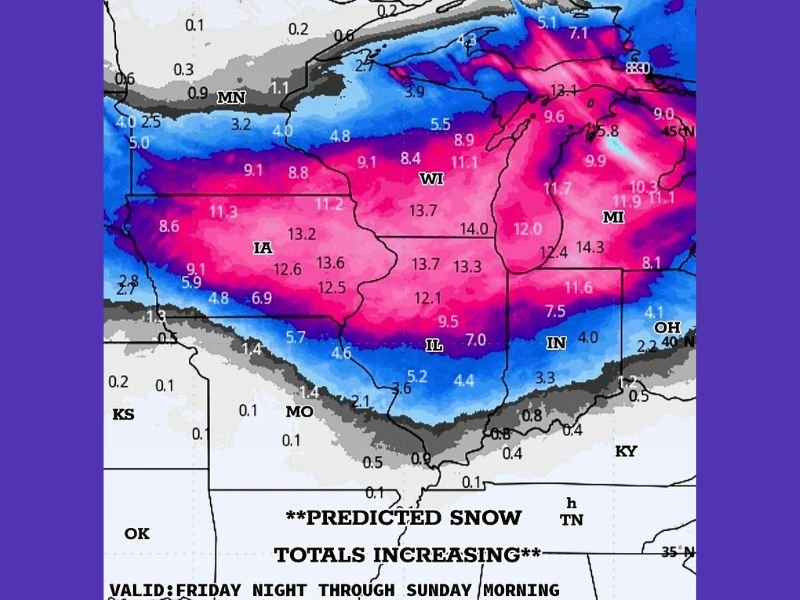
According to the latest projections, eastern Iowa, southern Wisconsin, and northern Illinois are expected to be hit hardest by the system. Many locations across these regions could see 12 to 14 inches of snow, with locally higher amounts possible depending on how the storm bands develop.
Forecast Overview
Meteorologists say the storm system will begin organizing late Friday night, with snow intensifying through Saturday morning and continuing into Sunday. The heaviest snowfall is expected during the Saturday evening to early Sunday timeframe, when strong atmospheric lift and colder air combine to produce steady, heavy snow.
Forecast models show:
- Iowa (IA): 10–13 inches in central and eastern areas, with some locations topping 14 inches.
- Wisconsin (WI): 11–13 inches expected across much of the southern and eastern regions.
- Illinois (IL): 8–14 inches possible, with the highest totals in the northern part of the state, including Rockford and the Chicago suburbs.
“Snowfall totals have continued to increase in recent model runs,” forecasters explained. “The atmosphere is primed for strong snowfall rates, especially late Saturday into early Sunday.”
Travel Impacts Expected
Road conditions are expected to deteriorate rapidly once snow begins Friday night. I-88, I-90, and I-94 could experience significant travel slowdowns due to accumulating snow and reduced visibility. Plow crews are preparing for extended operations through the weekend.
Drivers are urged to:
- Avoid unnecessary travel during peak snowfall hours.
- Keep emergency kits, blankets, and extra fuel in vehicles.
- Monitor updated advisories and road condition alerts throughout the storm.
Air travel through Chicago O’Hare and Midway Airports could also face delays and cancellations, especially Saturday night into Sunday.
Temperature and Wind Conditions
Temperatures will stay below freezing for most of the storm duration, ensuring that snow accumulates efficiently. Winds are expected to range between 15–25 mph, creating areas of blowing and drifting snow that may reduce visibility, particularly in rural and open areas.
By late Sunday, the system will gradually push east toward Michigan and northern Indiana, but lingering flurries could continue into Monday morning.
Looking Ahead
After the storm moves out, temperatures will remain chilly through the start of next week, with highs only in the 20s and 30s. A brief break in precipitation is expected before another potential winter system could approach midweek.
Stay connected with NapervilleLocal.com for real-time updates on snowfall totals, travel conditions, and official weather advisories throughout the weekend.

I’ve lived in Naperville long enough to see how quickly our community changes — from new developments downtown to sudden shifts in our Midwest weather. Reporting on Naperville news and daily forecasts gives me the chance to keep neighbors informed about what really matters. My goal is simple: deliver clear, timely updates so you always know what’s happening in our city and what to expect from the skies above.