
Historic 2026 Nor’easter Slams Rhode Island, Massachusetts, New York and New Jersey with 3-Foot Snowfalls After Bomb Cyclone Tracks Perfectly Along I-95 Benchmark
RHODE ISLAND — The blizzard of 2026 is already being called a once-in-a-generation event after a powerful Nor’easter rapidly intensified into a true bomb cyclone and delivered historic snowfall totals across the Northeast.
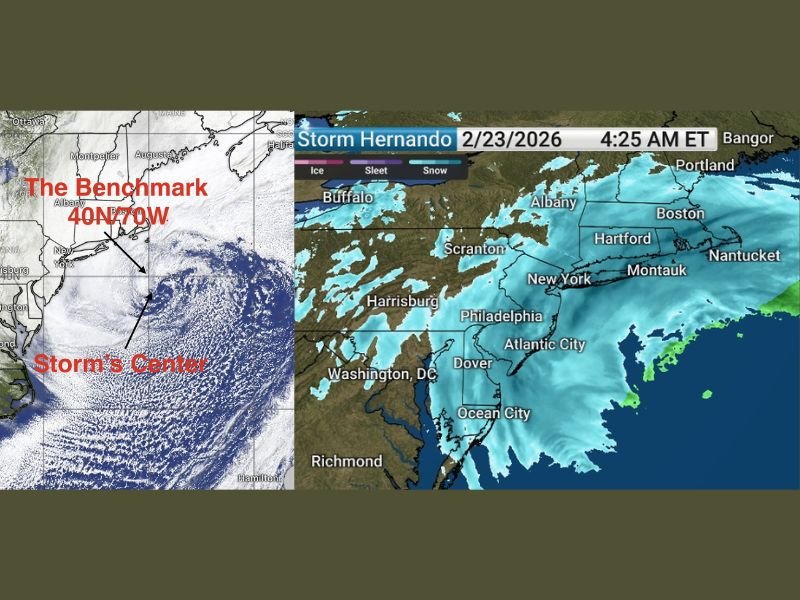
The storm deepened dramatically, dropping 41 millibars in just 24 hours, meeting the criteria for explosive cyclogenesis. Its track near the critical 40°N / 70°W benchmark — often considered the ideal position for maximizing snowfall along the I-95 corridor — helped produce widespread double-digit totals from New Jersey through New England.
Rhode Island May Have Set a New State Record
In Providence, Rhode Island, snowfall reached an astonishing 37.9 inches, potentially setting a new all-time state record, pending quality control review. That total surpassed the legendary Blizzard of 1978 and solidified the storm’s place in regional history.
Other top reports included:
- Whitman, MA: 33.7 inches
- Islip, NY: 31.0 inches
- North Stonington, CT: 30.8 inches
- Lyndhurst, NJ: 30.7 inches
In many communities, snowfall exceeded two feet, with some locations approaching or topping three feet.
New York City Buried, But Records Stand
While some areas set records, New York City’s Central Park measured 19.7 inches, making it the city’s ninth-largest snowfall on record and the biggest in roughly a decade. Nearby airports recorded even higher totals:
- JFK Airport: 20.1 inches
- LaGuardia Airport: 22.5 inches
- Newark Airport: 27.1 inches
Interestingly, meteorologists note that five of New York City’s ten largest snowstorms have occurred within the last decade, underscoring how active recent winters have been. Official snowfall records for NYC date back to 1869.
Benchmark Track Made the Difference
Satellite imagery confirmed that the storm center passed almost directly over the 40N/70W benchmark — a position known to maximize snowfall for Boston, New York, and much of coastal New England. This precise track allowed the heaviest snow bands to align along the I-95 corridor, intensifying accumulation rates and extending heavy snowfall inland.
Forecasters initially described the outlook as uncertain, with projections ranging widely. However, as the storm evolved, it overperformed expectations in several areas, delivering totals beyond early forecasts.
A Blizzard That Will Be Remembered
The 2026 Nor’easter stands out not only for its snowfall totals but for its rapid intensification and textbook track. The combination of explosive strengthening and near-perfect positioning created ideal conditions for a historic snow event across multiple states.
While Illinois was spared the direct impacts of this storm, events like this highlight how powerful winter systems can reshape records and rewrite history along the East Coast. NapervilleLocal.com will continue to monitor major national weather events that could influence broader seasonal patterns or future Midwest impacts.

I’ve lived in Naperville long enough to see how quickly our community changes — from new developments downtown to sudden shifts in our Midwest weather. Reporting on Naperville news and daily forecasts gives me the chance to keep neighbors informed about what really matters. My goal is simple: deliver clear, timely updates so you always know what’s happening in our city and what to expect from the skies above.