
Hit-or-Miss Showers and Sub-Severe Afternoon Storms After 3 PM Greet Philadelphia, Harrisburg, and Pittsburgh as Pennsylvania’s Warmest Week of the Year Kicks Off
HARRISBURG, Pa. — Pennsylvania is stepping into a warmer and more active stretch of weather to open the week, with high temperatures climbing into the 70s and low 80s across most of the state today.
While the forecast map may look intimidating at first glance, forecasters are quick to reassure residents that today will not be nearly as bad as it appears — plenty of dry periods are expected throughout the day, and any storm activity will remain sub-severe. The real weather story is the hotter week building ahead with more significant storm chances on the horizon.
Two Zones, Two Different Storm Experiences Today
Pennsylvania is divided into two distinct weather zones for Monday, each carrying a different character of storm threat through the day.
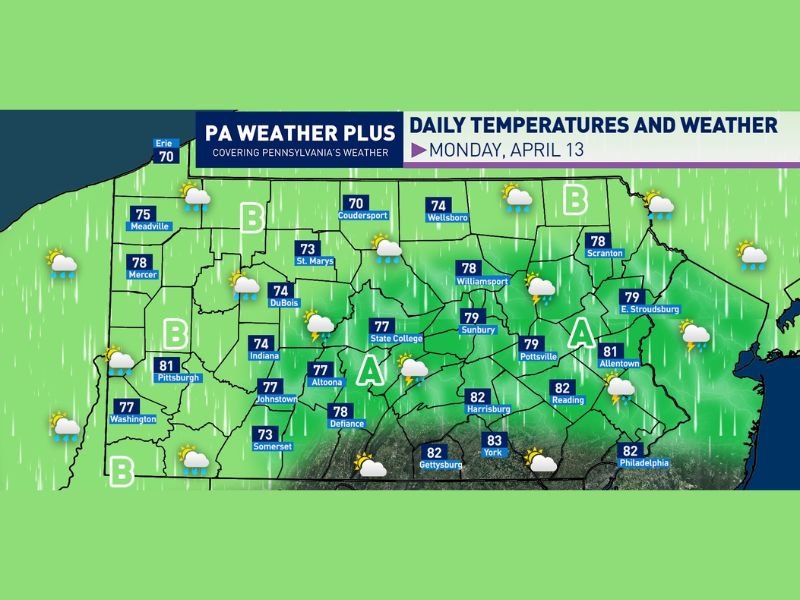
Area A covers central and eastern Pennsylvania — including Harrisburg, York, Allentown, Reading, Sunbury, Pottsville, East Stroudsburg, and Williamsport. This zone faces the more active threat, with hit-and-miss showers possible through the morning and early afternoon before a few storms fire up after 3 PM and into the evening hours. Any storms that develop will remain sub-severe, but residents should still expect a rumble of thunder and brief downpours during the afternoon window.
Area B covers western and northern Pennsylvania — including Pittsburgh, Washington, Meadville, Mercer, DuBois, Indiana, Johnstown, Erie, Coudersport, and Wellsboro. This zone will see a few scattered showers through the morning and early afternoon alongside a mix of sun and clouds. An isolated shower or rumble of thunder is possible after 3 PM, but the best and most organized storm threat stays confined to Area A to the east.
Temperatures Surge Into the 70s and Low 80s Statewide
The warmup that Pennsylvania has been building toward arrives in earnest today, with temperatures reaching levels that would feel more at home in late May than mid-April. The southeast corner of the state is running the warmest, with York topping out at 83°F, Gettysburg at 82°F, and Philadelphia, Harrisburg, and Reading all reaching 82°F.
Central Pennsylvania communities including State College hit 77°F, Altoona reaches 77°F, and Williamsport climbs to 78°F. Western Pennsylvania sees Pittsburgh at 81°F and Mercer at 78°F, while northern tier communities run cooler with Erie at 70°F, Coudersport at 70°F, and Somerset at 73°F.
Plenty of Dry Time to Get Outside Today
Despite the storm chances and unsettled look to the forecast, there will be a significant amount of dry time built into Monday for residents looking to get outdoors and enjoy the milder conditions. Morning hours will offer the best windows of dry weather before shower chances gradually increase through the midday period.
The afternoon storm window after 3 PM is the primary period to watch, but even then, storm coverage will be scattered and hit-or-miss rather than widespread and unavoidable.
Hotter Week Ahead With Growing Storm Chances
Monday’s warmth is just the opening act. A hotter week lies directly ahead for Pennsylvania, with temperatures expected to climb further as the week progresses alongside increasing storm chances. Residents should stay tuned for updated forecasts as the week develops and the pattern becomes more defined. Stay with NapervilleLocal.com for the latest weather updates and local forecast coverage.

I’ve lived in Naperville long enough to see how quickly our community changes — from new developments downtown to sudden shifts in our Midwest weather. Reporting on Naperville news and daily forecasts gives me the chance to keep neighbors informed about what really matters. My goal is simple: deliver clear, timely updates so you always know what’s happening in our city and what to expect from the skies above.