
Illinois, Alaska and Hawaii Highlight NOAA’s Mid-February “Thaw” Shift as Most of the U.S. Trends Warmer
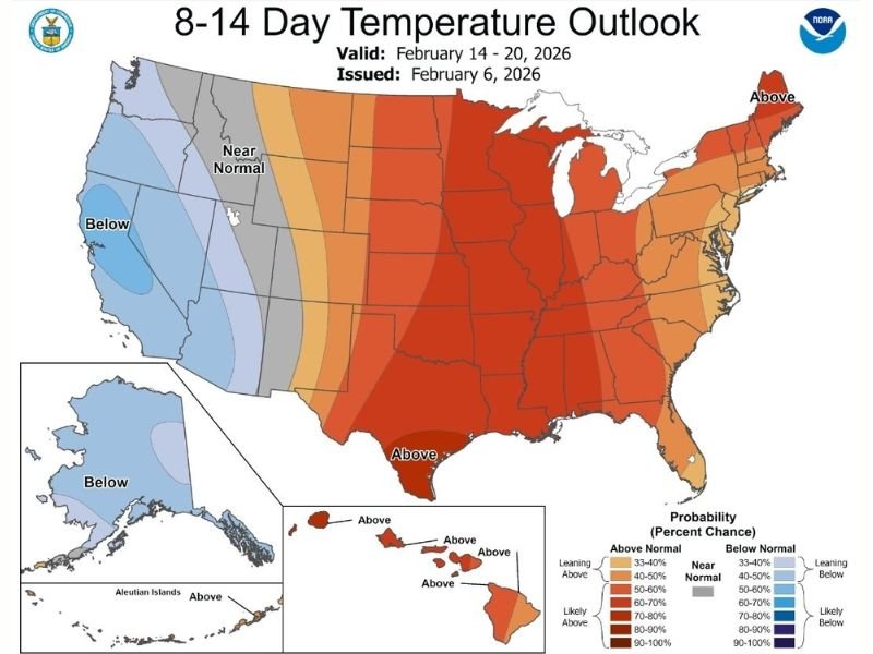
UNITED STATES — A major temperature pattern change may be on the way across the country after weeks of persistent chill, according to NOAA’s 8–14 Day Temperature Outlook. The map, valid Feb. 14–20, 2026 and issued Feb. 6, 2026, shows a broad push toward above-normal temperatures across much of the central and eastern United States, including Illinois, while parts of the western U.S. lean closer to normal or below normal. The outlook also shows Alaska trending below normal, with Hawaii favored to run above normal.
NOAA Outlook Shows Above-Normal Temperatures Dominating the Central and Eastern U.S.
The strongest warm signal is centered over the heart of the country and spreads eastward, indicating higher odds that many states will run warmer than typical mid-February averages. For areas in the Midwest and Great Lakes region, including Illinois, that kind of outlook often aligns with what people call a “January thaw,” just arriving later on the calendar.
This doesn’t guarantee spring weather, but it does suggest the background pattern could shift away from the harsh cold that’s dominated in recent weeks.
The West Is Not in the Same Warm Pattern
While the central and eastern U.S. lean warmer, the outlook shows the West with more neutral shades and pockets of cooler-than-normal probability. In practical terms, that means the West may not experience the same widespread warm-up at the same time, and some areas could stay cooler compared with the rest of the country.
That contrast is important because it’s one of the reasons the national map looks so dramatic: a warm-leaning east and a more restrained or cooler-leaning west.
Alaska Trends Colder While Hawaii Leans Warmer
The outlook map flags Alaska in the cooler-than-normal category, suggesting colder conditions remain favored there during the outlook window. Hawaii, meanwhile, is shaded for above-normal temperatures, indicating the odds favor a warmer-than-average stretch.
What This Could Mean for Winter Impacts Nationwide
A nationwide warm lean in mid-February can change how winter behaves across many regions. In the warmer-leaning areas, it can increase the likelihood of snowmelt, slush, and refreeze cycles, while also lowering the odds of prolonged subfreezing daytime highs. In areas that stay cooler, winter hazards can hold on longer and cold-sensitive travel issues can remain more persistent.
Even with a warmer signal, NOAA outlooks don’t rule out short-lived cold shots or individual storms. The map is about the most likely temperature trend over several days, not a guarantee for any single afternoon.
Why This Forecast Can Still Shift
The text on the image itself points to “changes on the way” and frames it as a pattern transition. These 8–14 day outlooks can still adjust as new data comes in, so the next few NOAA updates will matter for confirming whether this warm signal holds steady or shifts west/east.
NapervilleLocal.com will continue tracking how this national warm-up signal evolves and whether it becomes a real break from winter cold or just a temporary thaw.

I’ve lived in Naperville long enough to see how quickly our community changes — from new developments downtown to sudden shifts in our Midwest weather. Reporting on Naperville news and daily forecasts gives me the chance to keep neighbors informed about what really matters. My goal is simple: deliver clear, timely updates so you always know what’s happening in our city and what to expect from the skies above.