
Illinois and Indiana Marked as Nation’s Highest Severe Storm Risk Thursday Night, CSU Model Highlights Midwest Bullseye
ILLINOIS — A newly released severe weather outlook from Colorado State University’s Machine-Learning Model is placing Illinois and Indiana at the center of the nation’s highest probability for severe storms Thursday into Thursday night.
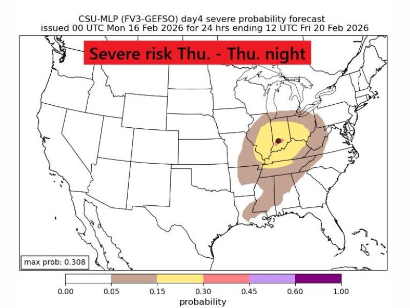
The CSU-MLP (FV3-GEFSO) Day 4 forecast highlights a concentrated risk area across parts of the Midwest and Ohio Valley. A black dot over central Illinois and western Indiana marks the highest modeled probability of severe weather anywhere in the country during the 24-hour period ending early Friday.
Midwest Bullseye: Illinois and Indiana
The model shows a broad risk area stretching from portions of Missouri and Arkansas northward into Illinois and Indiana, with the strongest signal centered near the Illinois-Indiana border.
Shaded probability zones indicate:
- A broader low-end risk extending into parts of Kentucky, Tennessee, and Mississippi
- A more focused moderate risk across central and eastern Illinois
- The highest probability zone over central Illinois into western Indiana
The model’s maximum probability value reaches just over 30%, which is notable for a forecast issued four days in advance.
What This Means for Naperville and Northern Illinois
While the highest probability zone appears centered slightly south of Chicago, northern Illinois — including the Naperville area — remains within the broader highlighted risk region.
At this range, specific storm timing and exact impact zones are still uncertain. However, when machine-learning guidance clusters probabilities this strongly several days out, it signals a potentially organized severe weather setup.
Typical threats in similar February patterns include:
- Damaging wind gusts
- Heavy rainfall
- Hail
- Isolated tornado potential
The exact hazard breakdown will become clearer as the event moves closer.
Why This Forecast Is Getting Attention
The CSU machine-learning model uses ensemble weather data to identify patterns historically associated with severe weather. When it isolates a concentrated bullseye like this — particularly with a black marker indicating the highest national probability — forecasters pay attention.
It does not mean severe weather is guaranteed, but it does suggest the atmospheric ingredients could align in a way supportive of strong storms.
Next Steps: Monitoring the Trend
With several days remaining before Thursday, additional updates from national forecasting agencies and local meteorologists will refine the outlook.
Residents across Illinois, Indiana, Kentucky, and surrounding states should:
- Monitor updated forecasts midweek
- Stay alert for potential watches or advisories
- Be prepared for rapid weather changes if storms develop
If the current signal holds, Thursday evening into Thursday night could bring the Midwest its most organized severe weather episode so far this season. For continuing Midwest weather coverage and national severe outlook analysis, follow updates at NapervilleLocal.com.

I’ve lived in Naperville long enough to see how quickly our community changes — from new developments downtown to sudden shifts in our Midwest weather. Reporting on Naperville news and daily forecasts gives me the chance to keep neighbors informed about what really matters. My goal is simple: deliver clear, timely updates so you always know what’s happening in our city and what to expect from the skies above.