
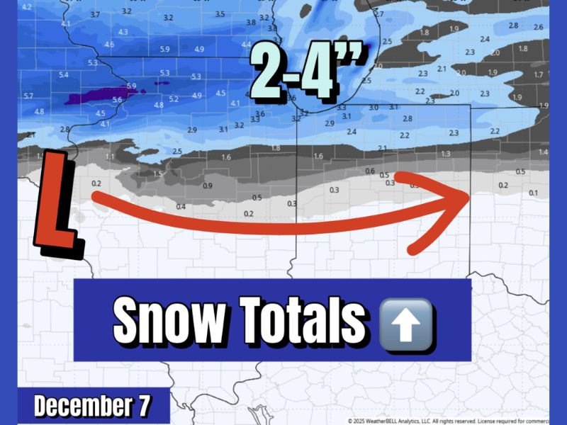
Illinois and Iowa to See 2–4 Inches of Snow Thursday Morning as Clipper System Moves East Toward Indiana and Michigan
ILLINOIS — Snow totals are trending higher across Iowa and northern Illinois as a clipper system moves through the Midwest Thursday morning, delivering a fresh coating of snow that will create slick roads and a wintry landscape. Meteorologists now expect most areas to receive 2 to 4 inches of accumulation, with a few isolated spots approaching 5 inches before the storm exits later in the day.
Clipper System Bringing Widespread Light to Moderate Snow
Forecasters say the compact low-pressure system, originating from the Northern Plains, will slide southeast overnight, spreading snow into eastern Iowa before sunrise and reaching northern Illinois, including the Chicago metro area, by mid-morning Thursday.
The heaviest snow bands are expected from Cedar Rapids and Waterloo, Iowa, to Rockford and DeKalb, Illinois, where totals could range from 3 to 5 inches due to locally enhanced snowfall rates. Farther south, including Peoria, Ottawa, and Kankakee, amounts will likely stay closer to 1 to 3 inches, tapering off through Thursday afternoon as the system moves into Indiana and Michigan.
Impacts on Travel and Commuting
Snow will accumulate quickly during the early morning hours, creating slippery and snow-covered roads during the Thursday morning commute. The National Weather Service warns that visibility may drop to under one mile at times in heavier snow bands, particularly across north-central Illinois and eastern Iowa.
Major highways, including Interstate 80, I-88, and I-39, are expected to see slow travel and patchy ice, especially where snow falls on cold pavement. Drivers are advised to allow extra travel time, reduce speeds, and use caution when approaching intersections and bridges, which may freeze faster than other surfaces.
In Chicago, light to moderate snow will likely continue through late morning before tapering to flurries by midday. While totals are not extreme, the timing of the snowfall could significantly impact morning and midday travel across the metro area.
Conditions to Improve by Afternoon
By Thursday afternoon, snow will gradually shift east into northern Indiana and southern Michigan, bringing a coating to 2 inches in those areas before tapering off completely by evening. Behind the system, skies will slowly clear, but temperatures will remain cold, with highs struggling to reach the upper 20s to low 30s.
Forecasters note that the quick movement of this system will limit total accumulations, but the fresh snowpack combined with overnight cooling could lead to slick roads again Thursday night as temperatures drop into the teens.
Looking Ahead
After Thursday’s snowfall, a short break is expected Friday before another potential weak clipper system moves through the region this weekend. While details are still developing, forecasters suggest the active pattern across the Midwest will likely continue through mid-December, keeping cold air and occasional snow chances in play.
Residents are encouraged to stay alert for weather updates and travel advisories as conditions evolve overnight. For real-time updates, snow maps, and safety guidance, visit NapervilleLocal.com for continued coverage across Illinois and Iowa.

I’ve lived in Naperville long enough to see how quickly our community changes — from new developments downtown to sudden shifts in our Midwest weather. Reporting on Naperville news and daily forecasts gives me the chance to keep neighbors informed about what really matters. My goal is simple: deliver clear, timely updates so you always know what’s happening in our city and what to expect from the skies above.