
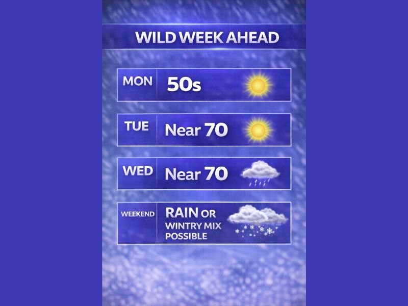
Illinois Faces a February Weather Whiplash: 50s Monday, Near-70 Warmth Tuesday–Wednesday, Then Rain and Possible Wintry Mix This Weekend
ILLINOIS — A classic February “roller coaster” pattern is lining up this week, starting with sunshine and temperatures in the 50s Monday, surging into near-70 warmth Tuesday and Wednesday, and then turning unsettled again as another system brings rain—with a track-dependent chance of a wintry mix heading into the weekend.
Monday Starts Mild and Bright
The week begins on a calmer note. The outlook shows sunshine with temperatures climbing into the 50s Monday—an early taste of springlike comfort after recent winter chill.
For Naperville and the western suburbs, that typically means a decent outdoor day, but it also sets the stage for what comes next: a stronger push of warm air arriving quickly behind it.
Near-70 Warmth Builds Tuesday and Wednesday
The most notable part of this forecast is the midweek jump. Tuesday and Wednesday are projected to surge to near 70 degrees, a level of warmth that can feel dramatic for early February in Illinois.
That kind of spike usually comes with a few practical impacts:
Warmer afternoons can melt leftover snow piles fast, creating standing water in low spots. It can also increase the contrast heading into the next system—because once temperatures swing hard in February, a quick reversal is always on the table.
Rain Returns, Then the Weekend Could Turn Messy
After the midweek warmth, the forecast points to another system moving in with rain. The bigger question is the weekend: the outlook notes that depending on the track, colder air could work back in and create a rain-to-wintry mix scenario.
Right now, the key uncertainty isn’t whether precipitation happens—it’s what form it takes when the next system arrives and how quickly colder air can wrap back into Illinois.
What to Watch as the Weekend Gets Closer
Instead of locking in a specific snow or ice call too early, it’s smarter to watch a few “tells” over the next several forecast updates:
- Whether overnight temperatures trend colder late week
- If the storm track shifts north (more rain) or south (higher wintry mix risk)
- How quickly colder air returns behind the midweek warm surge
What This Means for Naperville Area Residents
For now, the most reliable takeaway is timing: enjoy the mild start and warm midweek, but plan for a wetter, potentially more complicated setup as the weekend approaches.
If you’re scheduling travel, kids’ sports, or outdoor plans, keep flexibility late week—because February systems can flip conditions quickly once the rain/wintry line is in play.
Have you noticed these big temperature swings where you live? Share what you’re seeing in Naperville and nearby towns in the comments on NapervilleLocal.com.

I’ve lived in Naperville long enough to see how quickly our community changes — from new developments downtown to sudden shifts in our Midwest weather. Reporting on Naperville news and daily forecasts gives me the chance to keep neighbors informed about what really matters. My goal is simple: deliver clear, timely updates so you always know what’s happening in our city and what to expect from the skies above.