
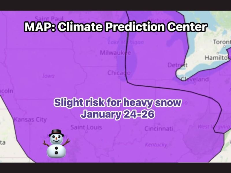
Illinois Flagged for a Growing Winter Threat as CPC Signals Heavy Snow Potential January 24–26
ILLINOIS — Winter may be preparing to make a stronger statement across the region later this month, as the Climate Prediction Center (CPC) has placed the entire area under a “slight risk” for heavy snow between January 24 and January 26, signaling an increasingly active winter pattern.
While this does not guarantee a major snowstorm, the designation highlights a window where one or more winter systems could impact Illinois, bringing accumulating snow if conditions align.
What a “Slight Risk” Really Means Right Now
The CPC outlook places Illinois firmly in what meteorologists refer to as the “pattern recognition” phase. At this stage:
- Confidence is increasing that winter systems will be present
- Exact details such as timing, storm tracks, and snowfall totals are still unclear
- The overall atmospheric setup is becoming more favorable for impactful snow
In short, the environment is turning colder and more active — even if specifics remain uncertain.
Multiple Systems Could Be Involved
Rather than a single storm, guidance suggests a couple of winter systems may move through the region during the January 24–26 time frame. This raises the possibility of:
- Widespread snowfall opportunities
- Periods of accumulating snow depending on storm placement
- A more dynamic winter pattern compared to earlier in the season
Meteorologists often watch these multi-system setups closely, as they can evolve quickly once higher-resolution data becomes available.
Why Confidence Is Still Limited
At this point, models have not yet locked in:
- Exact snowfall amounts
- Which areas could see the heaviest impacts
- Whether snow falls in one main event or multiple waves
That uncertainty is normal this far out, but the CPC highlighting the region this early is a notable signal that winter may be ready to “turn the dial up.”
What Happens Next
As the event window gets closer:
- Forecast confidence will increase
- Snow placement and intensity will become clearer
- Updates may shift risk levels higher or lower
For now, this is an early heads-up, not a final forecast — but it’s one worth paying attention to.
Bottom Line
Illinois is entering a stretch where winter weather threats are becoming more organized and more frequent, with late January shaping up as a potentially active period. While nothing is locked in yet, the signals are strong enough to keep snow on the radar. For continued Illinois winter weather updates, storm timing, and local impacts, stay connected with NapervilleLocal.com.

I’ve lived in Naperville long enough to see how quickly our community changes — from new developments downtown to sudden shifts in our Midwest weather. Reporting on Naperville news and daily forecasts gives me the chance to keep neighbors informed about what really matters. My goal is simple: deliver clear, timely updates so you always know what’s happening in our city and what to expect from the skies above.