
Illinois Indiana and Ohio Brace for Thursday Severe Storm Setup With Supercells and Very Large Hail Risk Up to 2 Inches
CENTRAL ILLINOIS — A developing severe weather setup is expected to impact parts of Illinois, Indiana, and Ohio on Thursday, with conditions favoring supercell thunderstorms capable of producing very large hail.
The setup is expected to form as a warm and moisture-rich air mass collides with an advancing cold front later in the day, creating an environment supportive of strong storm development.
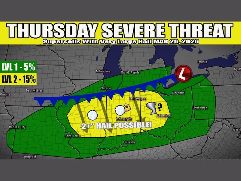
Central Illinois Indiana and Ohio in Primary Risk Zone
Forecast guidance highlights a corridor stretching from central Illinois through Indiana and into Ohio as the main area of concern.
Cities including Indianapolis and Columbus fall within the highlighted zone, with surrounding regions also facing an elevated risk of severe storms.
Supercells Could Produce Very Large Hail
The primary concern with this system appears to be large to very large hail, potentially exceeding 2 inches in diameter in some areas.
The setup is expected to favor supercell storm structures, which are known for producing intense updrafts capable of generating significant hail.
Strong Wind Shear Supports Organized Storms
Atmospheric conditions show strong bulk shear in place, which increases the likelihood of organized storm development. This type of environment can allow storms to become more structured and long-lasting, increasing the risk of severe weather impacts.
Tornado Risk Not Primary But Cannot Be Ruled Out
While the current setup does not strongly signal a widespread tornado outbreak, the presence of supercells means an isolated tornado cannot be completely ruled out.
Any rotating storm that develops could still pose a localized tornado risk, especially as the cold front forces storm initiation.
Cold Front Expected to Trigger Storm Development
The advancing cold front will act as the main trigger for storm formation later in the day Thursday. As the front pushes into the warm and unstable air mass, storms are expected to develop and intensify along the boundary.
What Residents Should Expect
Residents across Illinois, Indiana, and Ohio should prepare for the possibility of strong storms developing later Thursday, particularly during the afternoon and evening hours.
Large hail could pose a risk to vehicles, roofs, and outdoor property, while strong storms may also bring gusty winds.
What Happens Next
Forecast details, including exact storm timing and intensity, will continue to be refined as newer data becomes available.
For now, the signal points to a focused severe weather threat across parts of the Midwest, with large hail as the primary concern. Stay with NapervilleLocal.com for continued updates as this Thursday severe weather setup develops across Illinois, Indiana, and Ohio.

I’ve lived in Naperville long enough to see how quickly our community changes — from new developments downtown to sudden shifts in our Midwest weather. Reporting on Naperville news and daily forecasts gives me the chance to keep neighbors informed about what really matters. My goal is simple: deliver clear, timely updates so you always know what’s happening in our city and what to expect from the skies above.