
Illinois, Indiana and Ohio Could See Early March Snow as Forecast Models Signal Potential Heavy Corridor March 1–2
Illinois — A developing storm system is raising the potential for a significant early March snowfall across portions of the Midwest, with forecast guidance highlighting a corridor stretching from Illinois into Indiana and Ohio during the March 1–2 timeframe. While exact totals remain uncertain, confidence is increasing regarding where the snow band may set up.
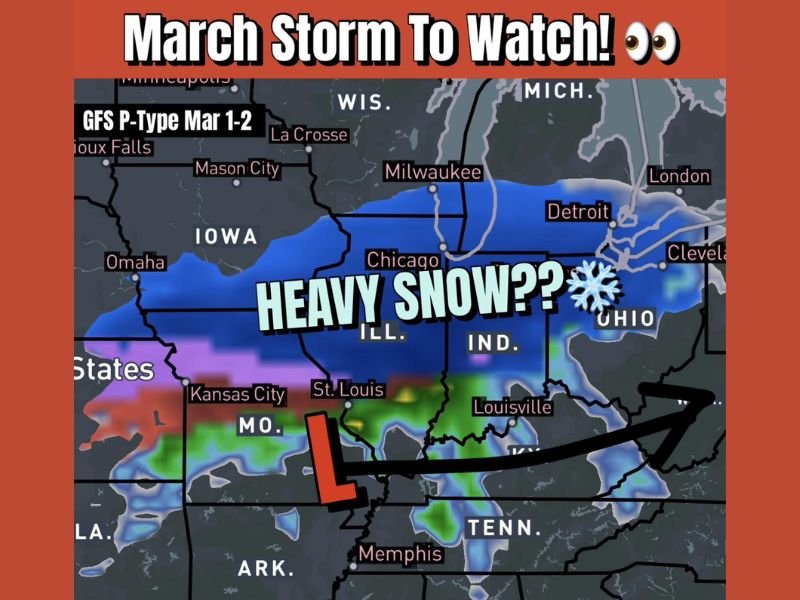
Recent model data shows a notable shift away from earlier warm-pattern discussions. The GFS model indicates a significant amount of snow, particularly across central and northern Illinois, extending eastward into northern Indiana and parts of Ohio. Meanwhile, the European (EURO) model shows lighter snowfall totals, but places the snow in a very similar geographic corridor. That alignment between two major global models strengthens confidence in the storm’s general placement.
What the Forecast Setup Shows
Forecast imagery depicts a low-pressure system developing over the central United States, tracking eastward while colder air remains positioned north of the system. On the northern side of the low, a broad swath of snow is projected across Illinois into Indiana and Ohio .
The GFS model paints deeper blue shading across parts of Illinois, suggesting the potential for heavier snowfall rates if the system intensifies. Areas farther south — including parts of Missouri and Kentucky — appear more likely to experience rain or mixed precipitation based on current projections.
Although the EURO model is less aggressive, it supports the idea of a defined snow corridor. When forecast models agree on where precipitation will fall as snow, forecasters gain higher confidence in impact zones — even if exact accumulation numbers are still fluctuating.
Why This Early March System Is Notable
March 1 marks the beginning of meteorological spring, making the timing of this system especially noteworthy. Many had anticipated a warmer transition into the new month, but updated guidance now points toward a more wintry start.
Late-season snow events are not unusual across Illinois, Indiana and Ohio. However, impacts depend heavily on storm strength and temperature profiles. Slight shifts in the track of the low-pressure system could significantly alter snowfall totals across the corridor.
Communities within the projected band could face:
- Periods of steady accumulating snow
- Reduced visibility during heavier bursts
- Slick travel conditions
- Rapid changes between rain and snow depending on temperature
At this stage, the key uncertainty remains the exact storm track and intensity. Forecasters will continue monitoring new model runs over the next several days to refine snowfall expectations.
Residents across Illinois, Indiana and Ohio should stay alert for updated forecasts as the March 1–2 window approaches. While not yet a guaranteed high-impact event, the increasing model agreement suggests this is a storm worth watching closely.
For continued regional weather updates and developing forecasts, visit NapervilleLocal.com for in-depth coverage.

I’ve lived in Naperville long enough to see how quickly our community changes — from new developments downtown to sudden shifts in our Midwest weather. Reporting on Naperville news and daily forecasts gives me the chance to keep neighbors informed about what really matters. My goal is simple: deliver clear, timely updates so you always know what’s happening in our city and what to expect from the skies above.