
Illinois, Indiana and Ohio Face Valentine’s Day Weather Whiplash as Euro Model Shift Raises Storm or Wintry Mix Risk
ILLINOIS — Valentine’s Day weekend weather across Illinois, Indiana and Ohio is shaping up to be highly uncertain as forecasters monitor a late-week storm system whose exact track could determine whether the region sees heavy rain and thunderstorms or a colder wintry mix. A noticeable overnight shift in the European weather model has added to the uncertainty, highlighting how sensitive the setup remains.
Meteorologists say the pattern supports rapid changes, beginning with a warm surge before colder air attempts to rush back into the region.
Warm-Up Expected Before a Sharp Late-Week Cooldown
Forecast guidance shows temperatures rising first across much of the central and eastern U.S., with some areas potentially reaching the 60s and even 70s ahead of the storm. That warmth is expected early to midweek, ahead of a strong cold front.
By Thursday into Friday, colder air is expected to push southward, setting up a narrow timing window that will determine how Valentine’s Day weekend unfolds.
Storm Track Will Decide Rain Versus Wintry Mix
Forecasters emphasize that the track of the low-pressure system is the deciding factor.
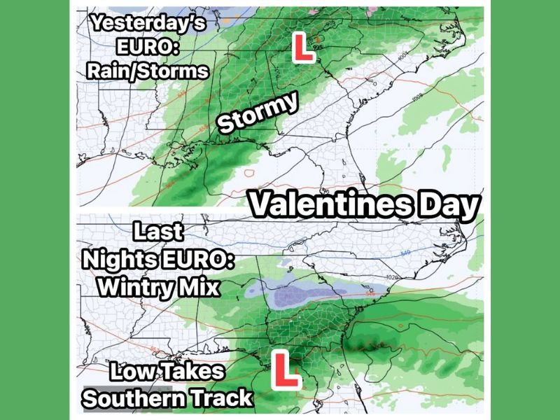
If the low tracks farther north, warmer air remains in place longer, favoring periods of heavy rain, gusty winds, and possible thunderstorms. If the low tracks farther south, colder air can slide in on the north side of the system, raising the potential for a wintry mix, especially in transition zones.
This type of setup often leads to sharp differences over short distances, with rain in one area and icy conditions in another.
European Model Shift Adds Forecast Uncertainty
Earlier European model runs leaned toward a more rain-dominant outcome. The latest run shifts the low farther south, increasing the chance that colder air interacts with moisture on the system’s northern edge.
That interaction is what raises concern for sleet, freezing rain, or a brief snow changeover, even if snowfall amounts remain limited.
What This Means for Illinois and the Midwest
Illinois and neighboring states frequently sit near the rain-snow line in systems like this. Small changes in storm position or timing can dramatically change impacts, particularly for travel.
Even without widespread winter weather, slick roads and rapid temperature drops could still create problems if colder air arrives while precipitation is ongoing.
Valentine’s Day Forecast Still Being Fine-Tuned
Forecasters stress there is still time to refine the forecast. Confidence is high that conditions will change, but lower on exact precipitation type and timing.
For now, Valentine’s Day weekend could trend:
- Milder and stormy with rain and thunderstorms, or
- Colder with a wintry mix on the north side of the system
Which outcome occurs will depend almost entirely on the storm’s final track over the next few days. NapervilleLocal.com will continue tracking forecast trends and provide updates as confidence improves.

I’ve lived in Naperville long enough to see how quickly our community changes — from new developments downtown to sudden shifts in our Midwest weather. Reporting on Naperville news and daily forecasts gives me the chance to keep neighbors informed about what really matters. My goal is simple: deliver clear, timely updates so you always know what’s happening in our city and what to expect from the skies above.