
Illinois, Indiana, Ohio, and Missouri Set for Springlike Warm-Up as Temperatures Surge Into the 50s and 60s This Week
ILLINOIS — After weeks locked in a persistent cold pattern, a dramatic temperature shift is taking shape across much of the Midwest and central United States, with Illinois, Indiana, Ohio, Missouri, and surrounding states preparing for their warmest stretch since before Thanksgiving.
Recent temperature analysis shows the region has endured 16 days with highs below 40 degrees, running nearly four degrees colder than average since late November. That streak is now ending as a broad surge of warm air pushes east, bringing conditions that may feel more like late March than early winter.
Why Temperatures Are Rising So Sharply
A strong atmospheric ridge is building over the central U.S., allowing warmer air from the southern Plains to surge northward. This setup is pulling temperatures well above seasonal norms across a wide swath of the country.
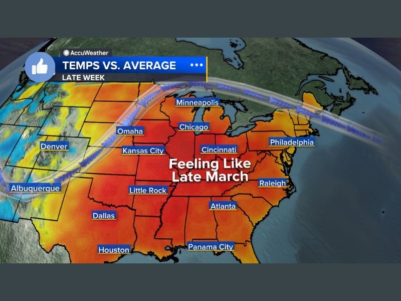
Forecast data indicates highs climbing into the 50s and even low 60s across Illinois, Indiana, Ohio, Missouri, Arkansas, Tennessee, and parts of the Mid-South. Cities such as Chicago, Cincinnati, Kansas City, Little Rock, and Atlanta are all positioned within the core of this warmth.
How Unusual This Warm Stretch Is
For many locations, this will be the warmest multi-day stretch in more than a month, marking a sharp contrast from the prolonged cold experienced since Thanksgiving. Afternoon temperatures will feel significantly milder, especially compared to recent days dominated by gray skies and sub-freezing highs.
While overnight lows may still dip into cooler territory, daytime conditions will be noticeably more comfortable, offering a brief reprieve from winter’s grip.
What Comes After the Warm-Up
Forecasters caution that this warm pattern may not last. Large temperature swings are common during winter transitions, and the same atmospheric setup driving the warmth could later open the door for renewed storm systems or colder air intrusions. For now, however, the focus is on the immediate change, which will impact daily routines, outdoor plans, and energy usage across the region.
What Residents Should Expect
Residents across Illinois and neighboring states can expect several days of above-average temperatures, reduced need for heavy winter gear during the afternoon, and conditions that feel more like early spring than mid-winter.
Stay alert for forecast updates as patterns evolve later in the week. For continued local weather coverage and Midwest forecast updates, follow NapervilleLocal.com and join the conversation by sharing how this sudden warm-up is affecting your plans.

I’ve lived in Naperville long enough to see how quickly our community changes — from new developments downtown to sudden shifts in our Midwest weather. Reporting on Naperville news and daily forecasts gives me the chance to keep neighbors informed about what really matters. My goal is simple: deliver clear, timely updates so you always know what’s happening in our city and what to expect from the skies above.