
Illinois, Indiana, Ohio, Kentucky and Tennessee Hit by Sudden Freeze as Arctic Air Surges Deep Into the South While Florida Stays Warm
UNITED STATES — A powerful surge of cold air is sweeping across the central and eastern United States, creating a dramatic temperature divide between freezing northern regions and comparatively warmer conditions along the Gulf Coast and Florida.
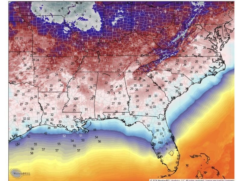
The latest weather maps show a sharp contrast stretching from the Midwest down through the Southeast, as winter-like air pushes aggressively southward.
Freezing Air Dominates Midwest and Ohio Valley
States across the Midwest and Ohio Valley are waking up to sub-freezing temperatures and biting cold conditions.
Widespread readings in the:
- Single digits and teens across Illinois, Indiana, and Ohio
- Low teens extending into Kentucky and West Virginia
are creating a harsh start to the day.
This cold air mass has surged south quickly, catching many areas off guard after recent milder conditions.
Sharp Temperature Gradient Across the South
One of the most striking features of this system is the intense temperature contrast across the southern United States.
Across:
- Tennessee, Arkansas, and northern Mississippi — temperatures are hovering in the teens and 20s
- Alabama and Georgia — readings range from the 20s to low 30s
Meanwhile, just a few hundred miles farther south:
- Louisiana and the Gulf Coast are in the 30s and 40s
- Florida is significantly warmer, with temperatures climbing into the 60s and even low 70s
This sharp gradient highlights how quickly conditions change over relatively short distances.
Cold Air Collides With Warm Gulf Waters
The advancing cold air is pressing into a region still influenced by warm Gulf moisture. Sea surface temperatures in the Gulf remain in the 50s to 70s, helping maintain milder conditions along coastal areas.
This clash between cold continental air and warm marine air is helping fuel instability along the boundary, which could contribute to additional weather developments in the coming days.
Wind Chill Making It Feel Even Colder
In addition to the cold temperatures, winds are making conditions feel even more uncomfortable.
Gusty conditions across the Midwest and Southeast are driving wind chills even lower than actual temperatures, particularly during the early morning hours. Residents across affected states are experiencing conditions that feel significantly colder than thermometer readings suggest.
Travel and Morning Impacts Across the Region
The cold snap is already impacting early morning routines across multiple states.
Officials warn that:
- Roads may become slick in colder regions
- Frost and freezing conditions could impact vehicles
- Morning commutes may be slower, especially in northern areas
The sudden drop in temperatures increases the risk of icy patches, particularly on bridges and elevated surfaces.
A Wide-Reaching Pattern Across the Eastern U.S.
This cold outbreak is part of a broader weather pattern impacting much of the eastern half of the country. From the Great Lakes down to the Gulf Coast, millions are feeling the effects of this system, whether through freezing temperatures or sharp temperature swings.
What Comes Next
Forecasters say this cold push may not last indefinitely, but it will dominate conditions in the short term.
Gradual moderation is expected in some areas later in the week, but for now, the focus remains on navigating the current cold snap safely.
Residents are advised to:
- Dress in layers
- Limit exposure to cold conditions
- Stay updated on local forecasts
Stay with NapervilleLocal.com for continued coverage of major weather changes affecting communities nationwide.

I’ve lived in Naperville long enough to see how quickly our community changes — from new developments downtown to sudden shifts in our Midwest weather. Reporting on Naperville news and daily forecasts gives me the chance to keep neighbors informed about what really matters. My goal is simple: deliver clear, timely updates so you always know what’s happening in our city and what to expect from the skies above.