
Illinois, Indiana, Ohio, Kentucky, Tennessee, Missouri Storm Pattern Builds Midweek With Cold Front and Gulf Moisture Bringing Days of Thunderstorms
CHICAGO, ILLINOIS — A major shift in the weather pattern is setting up across the central and eastern United States, with multiple days of storms expected from the Midwest into the South and Ohio Valley. After a stretch of warmer conditions, a strong cold front and increasing moisture will bring repeated chances for rain and thunderstorms through much of the week.
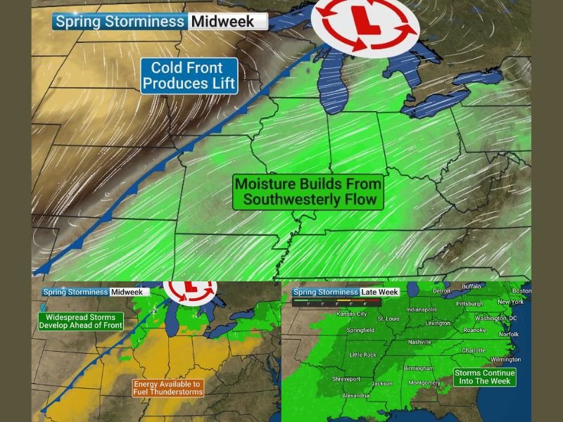
Cold Front Triggers Widespread Storm Development
A developing cold front moving across the Plains into the Midwest will act as the main trigger for storm activity. As this boundary advances eastward, it will interact with warmer, unstable air already in place across states like Illinois, Indiana, and Missouri. This setup is expected to lead to widespread thunderstorm development, especially during the midweek period.
Gulf Moisture Fuels Storm Intensity
At the same time, strong southerly winds are pulling moisture northward from the Gulf of Mexico. This moisture surge will increase humidity levels and provide the fuel needed for storms to strengthen.
Areas across Kentucky, Tennessee, and the lower Midwest will see this moisture build, enhancing rainfall potential and storm coverage.
Midwest and Plains Face Active Storm Day Tuesday
Tuesday is shaping up to be one of the more active days, particularly across parts of the Plains and Midwest. Storms are expected to develop ahead of the cold front and spread eastward into Illinois, Indiana, and surrounding regions. These storms could vary in intensity, with some capable of producing heavier rain and gusty winds.
Multi Day Storm Pattern Sets In
Unlike a single storm system, this pattern is expected to remain in place for several days. From midweek into late week, waves of showers and thunderstorms will continue to move through the region. This means off-and-on rainfall rather than continuous storms, but with repeated impacts over time.
Rain Could Help Reduce Drought and Pollen Levels
The increased rainfall may provide some relief from ongoing dry conditions in parts of the region. Additionally, the rain could help reduce high pollen levels that have been affecting many areas during early spring. However, localized heavier storms could still cause temporary disruptions.
What Residents Should Expect
Residents across Illinois, Indiana, Ohio, Kentucky, Tennessee, and Missouri should prepare for a more active weather pattern with multiple chances for storms through the week. While not every day will bring severe weather, the repeated rounds of rain and thunderstorms could impact travel and outdoor plans.
Stay with NapervilleLocal.com for continued updates, forecast breakdowns, and real-time alerts as this multi-day storm pattern develops across the Midwest and beyond.

I’ve lived in Naperville long enough to see how quickly our community changes — from new developments downtown to sudden shifts in our Midwest weather. Reporting on Naperville news and daily forecasts gives me the chance to keep neighbors informed about what really matters. My goal is simple: deliver clear, timely updates so you always know what’s happening in our city and what to expect from the skies above.