
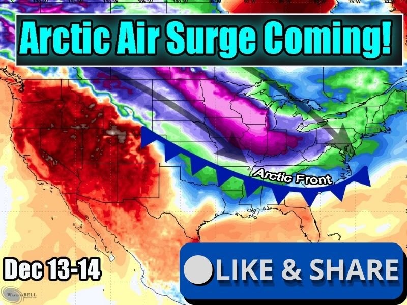
Illinois, Iowa, Missouri, and Nebraska to Face Arctic Air Surge Dec. 13–14 With Temperatures 30–40 Degrees Below Normal
ILLINOIS — Another Arctic blast is set to sweep through the Midwest and Central Plains this weekend, bringing a sharp temperature plunge across Illinois, Iowa, Missouri, and Nebraska. Forecasts show temperatures could run 30 to 40 degrees below average between December 13–14, extending the region’s early-season deep freeze.
Bitter Cold to Grip the Midwest and Plains
Meteorologists report that a new Arctic air mass is gathering momentum in the northern polar regions and will surge southward late Friday. By Saturday morning, subfreezing air will dominate the Northern Plains and Midwest, spreading into Missouri and down toward Arkansas by Sunday.
The coldest air will center over Iowa, Nebraska, and northern Illinois, where daytime highs could struggle to climb out of the teens and lower 20s. With gusty north winds, wind chills may plunge below zero in several rural areas.
“This Arctic air is straight out of the Yukon,” forecasters explained, “and it will deliver a shock to anyone stepping outside without preparation.”
30–40°F Below Normal in Core Zones
Forecast models indicate the temperature plunge will be most extreme across Nebraska, Iowa, Missouri, and Illinois, where anomalies will reach up to 40°F below normal. Cities including Chicago, Des Moines, Kansas City, and St. Louis could experience one of their coldest early-December weekends in years.
Even farther south, areas of Arkansas, northern Texas, and Tennessee may feel the edge of the Arctic front, with overnight lows in the upper 20s and 30s.
Gusty Winds and Dangerous Wind Chills
The Arctic boundary will be accompanied by northwest winds gusting up to 30 mph, reinforcing the cold and creating hazardous travel conditions. As the front pushes east, snow flurries or squalls could briefly reduce visibility in parts of the Midwest and Ohio Valley.
Drivers are urged to use caution on untreated roads, which could quickly ice over during the sharp temperature drop.
Another Arctic Outbreak Follows a Frigid Pattern
This upcoming cold surge marks the second major Arctic outbreak in two weeks, part of a persistent northern jet stream pattern allowing frigid Canadian air to spill southward.
While a brief warm-up is expected midweek, experts say another blast could follow before the month’s end — ensuring the Midwest winter of 2025 stays brutally active.
Stay with NapervilleLocal.com for continued coverage and local updates on the Arctic front impacting Illinois, Iowa, Missouri, and Nebraska this weekend.

I’ve lived in Naperville long enough to see how quickly our community changes — from new developments downtown to sudden shifts in our Midwest weather. Reporting on Naperville news and daily forecasts gives me the chance to keep neighbors informed about what really matters. My goal is simple: deliver clear, timely updates so you always know what’s happening in our city and what to expect from the skies above.