
Illinois, Michigan, Ohio, Wisconsin, Minnesota, and the Dakotas to Face Life-Threatening -20° to -35° Wind Chills Sunday Morning
ILLINOIS — A powerful Arctic outbreak will send wind chills plummeting across Illinois, Michigan, Ohio, Wisconsin, Minnesota, North Dakota, and South Dakota, with early Sunday morning “feels-like” temperatures falling to dangerous, frostbite-inducing levels between -20°F and -35°F, according to new hour-by-hour projections.
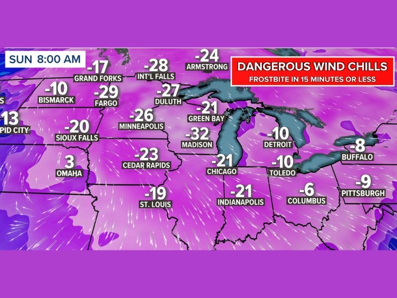
Wind Chills Capable of Causing Frostbite in 15 Minutes or Less
Meteorologists warn that the combination of subzero air temperatures and strong winds will create extreme cold conditions across the western Great Lakes and Northern Plains. The most severe wind chills are expected around 8:00 a.m. Sunday, when the core of the Arctic air mass settles over the region.
The updated forecast shows some of the most hazardous readings of the season so far:
- Fargo: -29°F
- International Falls: -28°F
- Duluth: -27°F
- Minneapolis: -26°F
- Madison: -32°F
- Chicago: -21°F
- Detroit: -10°F
- Buffalo: -8°F
- Toledo: -10°F
- Indianapolis: -21°F
Conditions like these mean that exposed skin can freeze within 10–15 minutes, making Sunday morning an especially high-risk period for anyone outdoors.
Northern Plains and Great Lakes Hit First by Deep Arctic Air
The coldest values will span Minnesota, the Dakotas, and northern Wisconsin, where the strongest Arctic winds align with the lowest temperatures. These regions will experience widespread -20° to -35° wind chills, delivering one of the harshest mornings of the winter season.
Even areas farther south — including Illinois, Indiana, and Ohio — will feel the sting of the Arctic blast, with wind chills dipping well below zero and creating hazardous conditions for morning commuters.
Travel, Outdoor Activities, and Early-Morning Work Could Be Dangerous
Meteorologists urge residents to limit time outdoors, especially during the early morning hours. Workers who start shifts before sunrise should ensure they wear insulated layers, face coverings, and thermal gloves.
Parents are also encouraged to take extra precautions with children who may be waiting for early buses on Monday, as residual cold will remain across the region even after Sunday’s bottoming-out point.
Warmer Weather Expected Later Next Week
There is some relief on the horizon. Forecast models indicate a significant warm-up arriving late next week, bringing temperatures back toward seasonal norms or even slightly above average for portions of the Midwest and Great Lakes.
However, forecasters stress that the immediate threat is severe and requires caution, particularly given how quickly frostbite can occur under these conditions.
For ongoing updates on major weather systems affecting the U.S., stay connected with NapervilleLocal.com.

I’ve lived in Naperville long enough to see how quickly our community changes — from new developments downtown to sudden shifts in our Midwest weather. Reporting on Naperville news and daily forecasts gives me the chance to keep neighbors informed about what really matters. My goal is simple: deliver clear, timely updates so you always know what’s happening in our city and what to expect from the skies above.