
Illinois, Missouri, Iowa, Wisconsin, Indiana Face Tornado Threat Tomorrow With Fast Moving Storms and Potential Significant Tornadoes Along Cold Front
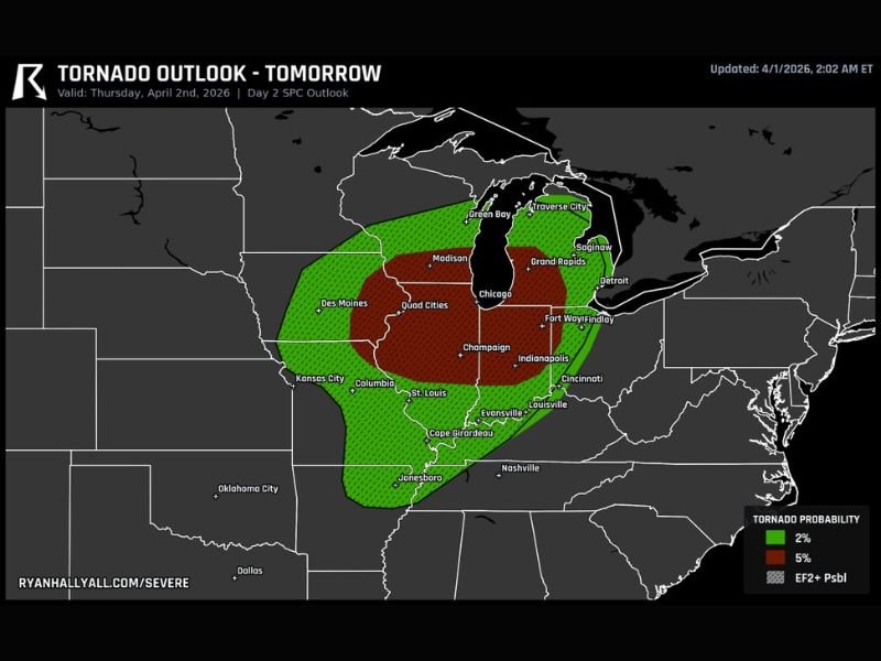
UNITED STATES — A developing severe weather setup is expected to bring a notable tornado threat across parts of the Midwest tomorrow, with the greatest concern stretching from northern Missouri into Illinois and surrounding states as a strong cold front sweeps through the region.
Forecasters are highlighting the potential for fast-moving storms capable of producing tornadoes, including the possibility of a few stronger, more significant events.
Tornado Risk Zone Expands Across Key Midwest States
The outlined risk area includes a broad corridor covering:
- Northern Missouri including areas near Kansas City and Columbia
- Central and northern Illinois, including Chicago and Champaign
- Eastern Iowa, including Des Moines and the Quad Cities
- Portions of Wisconsin, including Madison and Green Bay
- Parts of Indiana, including Indianapolis and Fort Wayne
This zone represents the area where atmospheric conditions will be most favorable for rotating storms.
Why This Setup Is Concerning
Even though instability is not expected to be extreme, strong wind shear and low-level spin will compensate, creating an environment supportive of tornado development.
Key ingredients include:
- A powerful cold front acting as a trigger
- Strong low-level winds enhancing rotation
- Fast-moving storm structures capable of producing quick spin-ups
This combination means storms may develop quickly and move rapidly, reducing warning times.
Timing Focused Into the Afternoon and Evening
The tornado threat is expected to evolve through the day:
- Afternoon: Storms begin developing along the advancing cold front
- Evening hours: Peak tornado risk as storms intensify and move east
- Overnight: Activity gradually shifts out of the region
Because storms will be moving quickly, impacts could arrive with little delay once storms form.
Potential Hazards Beyond Tornadoes
In addition to tornado risk, storms may also bring:
- Damaging straight-line winds
- Large hail
- Heavy rain in localized areas
However, the primary concern remains embedded tornadoes within fast-moving storm lines, which can be harder to detect.
Illinois and Surrounding Areas Should Stay Alert
Communities across Illinois, especially central and northern regions, should remain particularly weather-aware as storms approach.
Cities including:
- Chicago
- Champaign
- Springfield
- Peoria
may experience rapidly changing conditions during the evening hours.
Fast Moving Storms Mean Short Reaction Time
One of the most important factors in this setup is storm speed. Fast-moving systems can:
- Reduce warning lead times
- Increase the risk of quick-developing tornadoes
- Make conditions change rapidly over short distances
Residents are advised to have multiple ways to receive warnings and a clear safety plan in place.
A High Impact Weather Day Ahead for the Midwest
While not every location will experience severe weather, the setup supports a corridor of impactful storms capable of producing tornadoes, particularly from Missouri into Illinois.
Preparedness will be key as this system develops. Stay with NapervilleLocal.com for continued severe weather updates and regional coverage.

I’ve lived in Naperville long enough to see how quickly our community changes — from new developments downtown to sudden shifts in our Midwest weather. Reporting on Naperville news and daily forecasts gives me the chance to keep neighbors informed about what really matters. My goal is simple: deliver clear, timely updates so you always know what’s happening in our city and what to expect from the skies above.