
Illinois Severe Storm Threat Builds as Missouri Storms Race East Toward Chicago With Hail, Damaging Winds and Possible Tornadoes
CHICAGO, ILLINOIS — A fast-moving line of severe storms is expected to develop across Missouri before racing east through Illinois Tuesday afternoon and evening, bringing the risk of damaging winds, hail and possible embedded tornadoes across parts of the state.
Forecast timing indicates the storms could begin forming around midday in Missouri before rapidly tracking eastward. Meteorologists say the system may reach the Illinois River region by mid-afternoon and continue intensifying as it pushes toward eastern Illinois and into Indiana later in the evening. Northern Illinois could also see a separate early-morning threat before the main severe weather arrives later in the day.
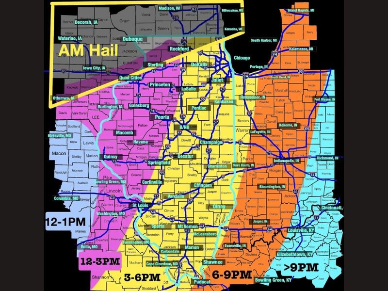
Early Morning Storms Could Bring Hail to Northern Illinois
Weather guidance shows a cluster of overnight storms moving across northern Illinois during the early morning hours. These storms are expected to pass through between 3 AM and 9 AM, with forecasters highlighting a corridor where hail may develop, especially across areas closer to the Wisconsin and Iowa borders.
Cities and regions that could see early storm activity include areas near Rockford, DeKalb and surrounding northern Illinois communities, though the morning storms are not expected to be the primary severe weather event of the day. Meteorologists say the morning activity could still produce brief hail and heavy rain before conditions temporarily stabilize later in the morning.
Main Severe Storm Line Expected to Form in Missouri
The primary severe weather event is forecast to begin across Missouri around midday, with storms developing roughly between 12 PM and 1 PM. From there, the system is expected to strengthen quickly as it pushes east across the Midwest.
Communities near St. Louis, Rolla and Farmington, Missouri could see storms develop first before they expand into a broader line capable of producing strong winds and rotating storms. Forecasters warn that once storms organize, they may move very quickly across Illinois.
Storms Expected to Reach Central Illinois by Mid-Afternoon
The line of storms is projected to arrive across central Illinois between roughly 3 PM and 6 PM. Cities including Springfield, Peoria, Champaign, Decatur and Effingham could see strong thunderstorms during this window.
Damaging straight-line winds are expected to be the primary hazard, though isolated tornadoes cannot be ruled out if embedded rotation develops within the storm line. Meteorologists say storm intensity may increase as the system continues tracking east across the state.
Eastern Illinois and Indiana Face Highest Tornado Risk
As the storm complex pushes into eastern Illinois and western Indiana during the evening hours, conditions may become more favorable for severe weather.
The strongest storms are expected between 6 PM and 9 PM, impacting areas including Terre Haute, Lafayette, Indianapolis and Bloomington, Indiana. Forecasters say the environment in eastern Illinois could support embedded tornadoes, particularly within fast-moving storm segments. Heavy rainfall, lightning and intense wind gusts may accompany the storms as they continue eastward.
Storms Expected to Move Toward Kentucky and Ohio Late Evening
After crossing Indiana, the severe weather system is expected to continue tracking east into Kentucky and parts of Ohio after 9 PM. Cities including Louisville and Bowling Green could experience late-night storms as the system gradually weakens while moving farther east.
Meteorologists continue monitoring the system closely as conditions evolve across the Midwest. Residents across Illinois, Indiana and neighboring states are advised to stay alert for weather updates throughout the day as the fast-moving storm line develops.
Stay with NapervilleLocal.com for continuing updates on this developing Midwest severe weather threat and additional forecasts affecting Illinois and surrounding states.

I’ve lived in Naperville long enough to see how quickly our community changes — from new developments downtown to sudden shifts in our Midwest weather. Reporting on Naperville news and daily forecasts gives me the chance to keep neighbors informed about what really matters. My goal is simple: deliver clear, timely updates so you always know what’s happening in our city and what to expect from the skies above.