
Illinois Severe Storm Threat Tuesday Afternoon: Tornadoes and Large Hail Possible From Peoria to Springfield as Storms Expand Toward Chicago Overnight
ILLINOIS — A volatile round of spring storms is expected to develop across Illinois Tuesday afternoon, with forecasters warning that central parts of the state could see the most intense weather between late afternoon and early evening before storms spread north overnight.
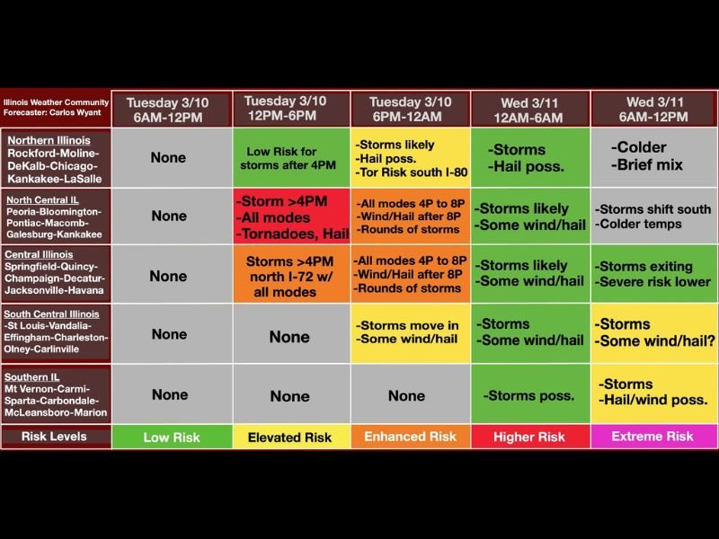
Early projections show the most concerning window developing between 4 PM and 8 PM across central Illinois, where atmospheric conditions may support multiple severe weather hazards including strong tornadoes and very large hail. Storms are expected to first form across areas such as Springfield, Champaign, Decatur, Quincy, and Jacksonville, then expand northward into the evening hours.
Storm Development Expected After 4 PM in Central Illinois
Most of Illinois will remain quiet through the morning and early afternoon Tuesday. However, weather conditions will begin changing quickly later in the day as instability increases across the region.
Forecast timing suggests storms could begin forming after 4 PM across central Illinois, particularly along and north of the Interstate 72 corridor. Cities including Springfield, Decatur, Champaign, and Quincy could see the first severe cells develop.
Meteorologists say that during this time frame all severe hazards are possible, including damaging winds, large hail, and tornadoes. The environment during the late afternoon period appears supportive of rotating storms capable of producing the strongest impacts.
Northern Illinois Storm Risk Builds Toward Evening
While the earliest storms will likely form farther south, the risk will gradually spread toward northern Illinois as the evening progresses.
Areas including Rockford, DeKalb, Chicago, Kankakee, Moline, and LaSalle could begin seeing storms later Tuesday evening. Forecast guidance indicates that storms may arrive in rounds, increasing the potential for hail and strong wind gusts, especially overnight.
Communities such as Peoria, Bloomington, Pontiac, Macomb, and Galesburg in north-central Illinois may experience storms beginning late afternoon and continuing into the nighttime hours.
While tornado risk may be lower in these northern areas compared with central Illinois, forecasters still warn that severe hail and damaging wind gusts remain possible.
Overnight Storm Rounds Expected Across Northern Two-Thirds of Illinois
Storm activity is expected to continue through the overnight hours across much of the northern two-thirds of Illinois.
Between roughly midnight and early Wednesday morning, additional waves of storms could move across northern regions including Chicago and Rockford. These storms may still produce hail and gusty winds, though the overall severe threat may begin gradually decreasing overnight.
Residents across northern and central Illinois should remain alert for rapidly changing weather conditions through the night.
Storms Shift South on Wednesday
By Wednesday morning, the main storm activity is expected to shift southward into southern and south-central Illinois, including areas such as Vandalia, Effingham, Charleston, Olney, Carlinville, Mount Vernon, Carmi, Carbondale, Marion, and Sparta.
These storms could still produce isolated hail and strong winds, though the overall severe weather risk appears lower compared to Tuesday evening’s peak window.
Northern Illinois, including Chicago and Rockford, may experience cooler temperatures with the possibility of a brief rain or wintry mix early Wednesday as colder air moves into the region.
Weather Pattern Still Being Fine-Tuned
Forecasters emphasize that the timeline remains an early outlook and could still change slightly as new forecast data becomes available. However, the late Tuesday afternoon through evening period in central Illinois currently appears to be the most concerning window for severe weather development.
Residents across Illinois are encouraged to monitor weather updates and be prepared for potential warnings as the storm system approaches. Forecast timing and risk details are based on the latest briefing guidance and early timing projections for the event.

I’ve lived in Naperville long enough to see how quickly our community changes — from new developments downtown to sudden shifts in our Midwest weather. Reporting on Naperville news and daily forecasts gives me the chance to keep neighbors informed about what really matters. My goal is simple: deliver clear, timely updates so you always know what’s happening in our city and what to expect from the skies above.