
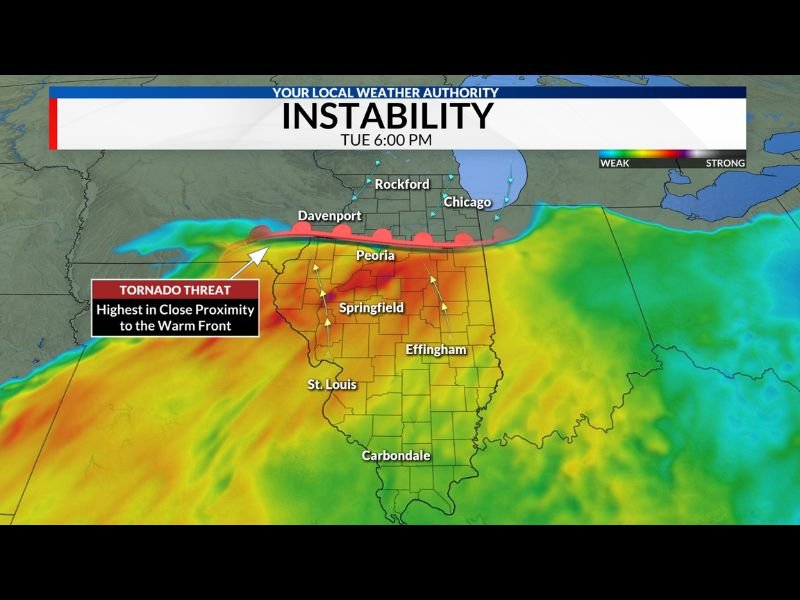
Illinois Severe Weather Setup: Warm Front Near Peoria and Springfield Could Determine Tornado Risk Tuesday Evening
ILLINOIS — A potentially dangerous severe weather setup could unfold across parts of Illinois Tuesday evening, with meteorologists closely monitoring where a warm front is expected to stall between Interstate 74 and Interstate 80, a boundary that may determine which communities face the highest tornado threat.
Forecast analysis suggests that a lake breeze coming off Lake Michigan could push the boundary slightly farther south than earlier expected. This interaction could cause the warm front to settle somewhere between the Peoria and Chicago corridor, dramatically influencing how storms behave as they develop. Communities along or just south of that boundary may face the greatest severe weather threat once storms begin forming later Tuesday.
Tornado Threat Highest Near the Warm Front
Meteorologists say the atmosphere south of the warm front will become very unstable, creating conditions favorable for severe thunderstorms capable of producing multiple hazards. Storms that develop on or near the warm front may have the highest chance of producing tornadoes, including potentially strong tornadoes in localized areas.
Cities that could fall near this critical zone include areas around:
- Peoria
- Springfield
- Davenport
- Regions stretching east toward Effingham
The exact position of the front will be crucial because even small shifts could change the type of severe weather a location experiences.
Storms North of the Boundary May Produce Large Hail
While tornadoes remain the primary concern near the warm front itself, storms that drift north of the boundary could behave differently.
Forecasters say storms that move into cooler air north of the front will likely produce large hail instead of tornadoes, due to different atmospheric conditions in that region. This means areas farther north toward Rockford and Chicago could see strong storms capable of producing hail even if tornado potential is lower.
Lake Michigan Could Influence Storm Placement
One major factor influencing the forecast is the lake breeze coming off Lake Michigan, which often pushes cooler air inland. This process can force weather boundaries like warm fronts slightly southward, changing where storms become strongest.
If the boundary shifts south closer to Interstate 80, the most dangerous storms could occur farther south across central Illinois. If it remains closer to Interstate 74, the severe threat zone may extend farther north.
Exact Storm Location Still Uncertain
Meteorologists say it is still too early to know exactly where the warm front will stall, and the final position may not become clear until Tuesday afternoon. That uncertainty means the difference between experiencing a tornado-producing storm or simply large hail could come down to a storm moving only a few miles north or south of the boundary.
Because of that uncertainty, residents across Illinois — especially those near Peoria, Springfield, Davenport, and surrounding areas — are encouraged to stay alert and monitor updated forecasts as the severe weather threat approaches. Forecasters emphasize that the atmosphere appears capable of producing significant severe weather, and preparation ahead of Tuesday evening will be important in case storms develop along the warm front.

I’ve lived in Naperville long enough to see how quickly our community changes — from new developments downtown to sudden shifts in our Midwest weather. Reporting on Naperville news and daily forecasts gives me the chance to keep neighbors informed about what really matters. My goal is simple: deliver clear, timely updates so you always know what’s happening in our city and what to expect from the skies above.