
Illinois, Texas, and Gulf Coast States to See Major Warmup Late Next Week After Early December Cold Snap
ILLINOIS — A major temperature rebound is on the way for much of the central and eastern United States, including Illinois, Texas, Louisiana, and Mississippi, as the nation transitions from an early-December cold snap to a broad mid-month warmup.
Meteorologists say a ridge of high pressure developing over the southern and eastern U.S. will allow warm air from the Gulf of Mexico to surge northward late next week, replacing the Arctic chill that dominated the start of December.
From Frost to Warmth Across the Heartland
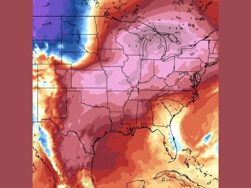
Forecast models from the NOAA and GFS show temperatures climbing 10 to 20 degrees above average across a large portion of the country beginning around December 13–17. The change will be most pronounced across:
- Illinois and the Midwest, where highs could reach the low-to-mid 50s
- Texas and Louisiana, expected to warm into the upper 60s to mid-70s
- Mississippi, Alabama, and Georgia, likely to see highs in the mid-60s to near 70°F
In Naperville and the greater Chicago area, afternoon temperatures may approach the 50s after several days of subfreezing mornings — a sharp contrast to the wintry start to December.
Warm Air Expanding Across the Central U.S.
This pattern is being driven by a northward shift in the jet stream, which will redirect cold air toward the northern Rockies and Pacific Northwest while opening the door for southerly winds and Gulf moisture across the central U.S.
The warm surge will extend from the southern Plains through the Midwest, expanding east into the Ohio Valley and Mid-Atlantic by the weekend. The setup will also bring a slight uptick in rain chances as the warmer air interacts with lingering moisture in the atmosphere.
Mild and Rainy, Not Wintry
While snow chances will persist north of the Great Lakes, most of Illinois, Texas, and Gulf Coast states will experience rain rather than snow under this warmer setup. Meteorologists say the next seven to ten days will feature:
- Above-normal temperatures throughout the Midwest and South
- Increased humidity along the Gulf states
- Scattered light rain or drizzle in parts of Texas, Mississippi, and Alabama
“After such a cold start to December, this upcoming warm spell will feel almost springlike for parts of the central and southern U.S.,” forecasters said.
What’s Next
The mid-December warmup is expected to last through December 17, followed by a gradual cooldown as the jet stream realigns. Some models hint at another push of colder Arctic air closer to Christmas week, which could return temperatures to seasonal or below-normal levels.
For now, residents across Illinois, Texas, and the broader Gulf Coast region can look forward to warmer afternoons, milder nights, and a temporary break from freezing temperatures.
Stay updated on the changing weather pattern and temperature outlook at NapervilleLocal.com.

I’ve lived in Naperville long enough to see how quickly our community changes — from new developments downtown to sudden shifts in our Midwest weather. Reporting on Naperville news and daily forecasts gives me the chance to keep neighbors informed about what really matters. My goal is simple: deliver clear, timely updates so you always know what’s happening in our city and what to expect from the skies above.