
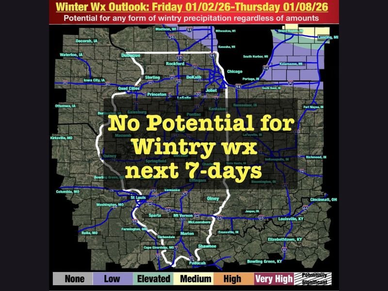
Illinois Weather Outlook Shows No Wintry Precipitation Expected for the Next 7 Days as 2026 Begins Mild and Dry
ILLINOIS — The first week of 2026 is set to begin on an unusually quiet note, with no snow or ice expected anywhere across Illinois from Friday, January 2 through Thursday, January 8. For early January, a period that typically features frequent winter systems, this prolonged stretch of dry and mild conditions stands out as highly uncommon. Forecast data shows the state locked into a stable pattern that will prevent wintry weather from developing for at least the next seven days.
A Rare January Break from Snow and Ice
Forecasters note that this level of calm weather is not something Illinois residents typically experience in January, a month known for active storm tracks and periodic lake-effect events. Instead, the next several days will feature milder temperatures, drier air, and a lack of any organized moisture, effectively shutting down snow chances statewide.
The Winter Weather Outlook map highlights “No Potential for Wintry Weather” across nearly all of Illinois, including major cities such as Chicago, Rockford, Joliet, Peoria, and Springfield. Even areas near the Wisconsin border—where January snowfall is usually more consistent—show minimal risk of icy or snowy conditions through next week.
Quiet Start to 2026 with Mild and Dry Conditions
As the new year begins, the pattern supports above-normal temperatures and stable high-pressure influence across the Midwest. This means roads will remain dry, travel will be smooth, and outdoor activities will be largely unaffected by winter hazards.
Early-week forecasts show daytime highs hovering in the upper 30s to mid-40s, while overnight lows stay relatively moderate for January. Such conditions reduce the likelihood of frost or freezing rain, further reinforcing the unusually benign forecast.
Residents may also notice reduced cloud cover and longer stretches of dry air, making this period a significant contrast from recent early-January weather patterns that have featured back-to-back winter systems in previous years.
Changes Possible Later Next Week, But Snow Still Appears Limited
While this week will remain quiet, meteorologists caution that the overall pattern may begin to shift toward the end of next week. Warmer and wetter conditions may return, which could reintroduce precipitation chances—though not necessarily snowfall at this stage.
Model trends indicate the atmosphere may become more active, but snow chances remain low in the near term. This aligns with a trend seen in recent years: winter is not ending, but it is taking an extended pause during early January.
A Mild and Unusual Week Ahead for Illinois
With the next seven days showing no measurable risk of wintry precipitation, Illinois residents can expect a calm, manageable start to 2026. While long-term winter conditions are far from over, this temporary break provides an opportunity to enjoy safer travel, milder temperatures, and a quieter weather pattern before the next active phase arrives. Stay with NapervilleLocal.com for updates throughout the week as Illinois transitions through this unusual mid-winter dry spell.

I’ve lived in Naperville long enough to see how quickly our community changes — from new developments downtown to sudden shifts in our Midwest weather. Reporting on Naperville news and daily forecasts gives me the chance to keep neighbors informed about what really matters. My goal is simple: deliver clear, timely updates so you always know what’s happening in our city and what to expect from the skies above.