
Illinois Winter Storm Threat Sunday Night Into Monday Could Bring Whiteout Conditions to Rockford, Galena, and Chicago With Blowing Snow
CHICAGO, ILLINOIS — A fast-moving winter storm is expected to sweep across Illinois late Sunday into Monday morning, bringing snow, powerful winds, and the potential for dangerous travel conditions across large parts of the state. Meteorologists say rain will transition to snow Sunday night as colder air rapidly moves in behind a storm system.
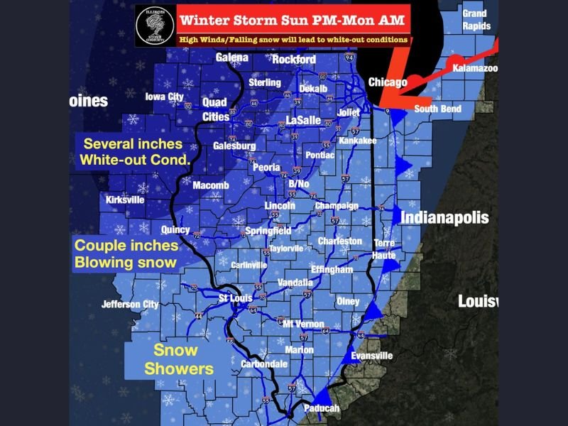
The combination of falling snow and strong winds could create near whiteout conditions in some areas, particularly across northern and northwestern Illinois.
Rain Changing to Snow Sunday Night Across Illinois
Forecasters say precipitation will begin as rain across parts of Illinois Sunday before colder air arrives overnight. As temperatures fall, that rain is expected to transition into snow across much of the state late Sunday night and into early Monday morning.
Snow showers are expected statewide, though snowfall totals will vary depending on location. Northern Illinois, including communities such as Rockford, Galena, Sterling, and the Quad Cities region, may see the most significant snowfall totals from the system.
Several Inches Possible in Northwestern Illinois
Forecast projections suggest several inches of snow could accumulate across northwestern Illinois, particularly near the Illinois–Iowa border. Cities including Galena, Rockford, and areas surrounding the Quad Cities could experience the heaviest snowfall from the storm.
Meanwhile, central and northeastern Illinois, including areas near Chicago, Joliet, DeKalb, and LaSalle, could see a couple inches of accumulation. Farther south across central and southern Illinois, lighter snowfall totals are expected with mainly snow showers.
Strong Winds Could Create Near Blizzard Conditions
Wind will play a major role in how disruptive the storm becomes. Forecasts indicate gusts between 30 and 45 miles per hour will develop as the storm moves through the region.
These winds could blow falling snow across roads and highways, reducing visibility and creating drifting snow in open areas. In some locations across northern Illinois, the combination of wind and snow could briefly create near-blizzard or whiteout conditions, especially overnight when visibility becomes more difficult.
Travel Impacts Likely Across Northern and Central Illinois
Meteorologists warn that travel conditions could deteriorate quickly Sunday night and early Monday. Rapidly falling temperatures behind the storm system could cause moisture on roads to freeze, creating icy surfaces. Blowing snow may also reduce visibility along highways throughout northern and central Illinois.
Cities such as Rockford, Peoria, Springfield, and Chicago could all experience periods of reduced visibility and slick road conditions during the storm.
Schools and Commutes Could Be Affected Monday Morning
Because the storm is expected to peak overnight and early Monday morning, the system could impact school schedules and the Monday morning commute across parts of Illinois. School officials in some districts may consider closures or delays if road conditions become hazardous early Monday.
Meteorologists say the storm’s exact snowfall totals will continue to be refined as updated forecast data becomes available. For now, residents across Illinois are encouraged to monitor weather updates and prepare for winter travel conditions Sunday night into Monday morning as the storm moves across the region.

I’ve lived in Naperville long enough to see how quickly our community changes — from new developments downtown to sudden shifts in our Midwest weather. Reporting on Naperville news and daily forecasts gives me the chance to keep neighbors informed about what really matters. My goal is simple: deliver clear, timely updates so you always know what’s happening in our city and what to expect from the skies above.