
Increasing Signal for Mountain Snow as Active Weather Pattern Sets Up Across the Northwest and Spreads Into the Intermountain West and Southwest by Mid-February
UNITED STATES — There is growing confidence among forecasters that western mountain snow prospects will improve beginning in about a week, as large-scale weather patterns begin transitioning into a more favorable setup for moisture across the western United States.
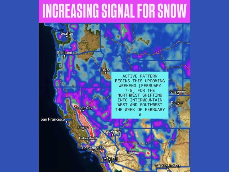
Guidance indicates the shift will start late next weekend across the Northwest, before gradually expanding inland into the Intermountain West and Southwest during the week of February 9. This transition marks a notable change after a quieter stretch for mountain snowfall in several western regions.
Pattern Change Signals Improving Snow Potential
According to the medium-range outlook, atmospheric flow is expected to slow and reorganize in a way that allows Pacific moisture to more effectively enter the western U.S. The earliest impacts are projected for the Northwest, with increasing precipitation signals showing up shortly thereafter farther south and east.
As this pattern matures, it could support multiple snow-producing systems, particularly in higher elevations, rather than a single brief event.
Northwest First, Then Inland Expansion
The provided forecast graphic highlights the progression clearly:
- Northwest: First region to see the active pattern arrive late in the upcoming weekend.
- Intermountain West: Moisture and snow chances increase as the pattern shifts inland.
- Southwest: Snow potential expands farther south as the week of February 9 unfolds.
This gradual transition suggests a sustained setup rather than a quick-moving storm, raising confidence in continued snowfall opportunities rather than isolated bursts.
Favorable Signals Extend Beyond Mid-Month
Medium-range guidance also suggests the pattern may remain favorable into mid-February and beyond, increasing the likelihood of repeated systems bringing snow to western mountain areas. While exact totals and locations will be refined closer to the event window, the overall trend points toward a more active and productive stretch for mountain snow.
For regions that rely on winter precipitation for water supply and snowpack, this shift could be a meaningful development. As conditions evolve and confidence increases, NapervilleLocal.com will continue tracking major weather pattern changes across the country and breaking down what they mean as systems come into clearer focus.

I’ve lived in Naperville long enough to see how quickly our community changes — from new developments downtown to sudden shifts in our Midwest weather. Reporting on Naperville news and daily forecasts gives me the chance to keep neighbors informed about what really matters. My goal is simple: deliver clear, timely updates so you always know what’s happening in our city and what to expect from the skies above.