
Indiana Alamo Gustnado Spins Up Dust Column Near Crawfordsville Triggering Tornado Warning With Dramatic Storm Structure
ALAMO, INDIANA — A striking storm feature known as a “gustnado” was spotted near Alamo in western Indiana, producing a visible dust column and briefly raising concerns that contributed to an earlier tornado warning. The phenomenon created a dramatic scene as strong winds kicked up dirt beneath an intense storm structure.
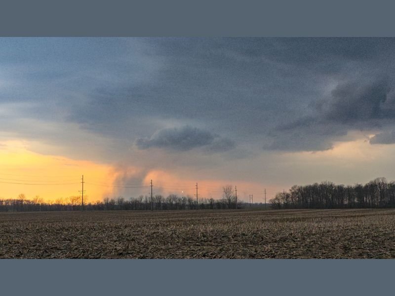
Gustnado Forms Near Alamo and Crawfordsville Area
The rotating column was observed near Alamo, not far from Crawfordsville, where strong outflow winds from a thunderstorm generated rotation at the surface. Unlike a traditional tornado, this type of circulation forms along the leading edge of storm winds rather than from a rotating cloud base. The result was a swirling column of dust clearly visible across open farmland.
What Makes a Gustnado Different From a Tornado
While visually similar at times, a gustnado is not considered a true tornado. It forms when powerful straight-line winds interact with localized boundaries, creating brief spin-ups near the ground.
These features typically do not connect to the storm’s main rotation aloft, but they can still appear intense and catch observers off guard.
Dust and Debris Create Dramatic Visuals
Photos from the scene show a well-defined dust plume rising beneath dark storm clouds, highlighting the strength of winds moving through the area. The contrast between the storm base and the illuminated horizon made the feature especially noticeable.
Open fields around Alamo allowed dust to be lifted easily, making the gustnado more visible than it might be in other environments.
Connection to Earlier Tornado Warning
The presence of strong winds and localized rotation likely contributed to radar signatures that prompted a tornado warning earlier in the area. While not a confirmed tornado, gustnado events can sometimes resemble more serious threats on radar and in real time. This underscores how quickly conditions can evolve during severe weather events.
What Residents Should Expect Next
Conditions across western Indiana remain active, with storms capable of producing strong winds and brief spin-up features. While gustnadoes are typically short-lived, they serve as a reminder of the unpredictable nature of severe storms.
Residents in and around Alamo and Crawfordsville should remain alert as additional storms move through the region. Stay with NapervilleLocal.com for continued severe weather coverage, real-time updates, and expert insights as storms develop across Indiana and beyond.

I’ve lived in Naperville long enough to see how quickly our community changes — from new developments downtown to sudden shifts in our Midwest weather. Reporting on Naperville news and daily forecasts gives me the chance to keep neighbors informed about what really matters. My goal is simple: deliver clear, timely updates so you always know what’s happening in our city and what to expect from the skies above.