
Indiana Braces for Severe Weather Sunday Followed by Rapid Temperature Crash and Dangerous Flash Freeze Risk
INDIANA — A fast-changing and potentially hazardous weather setup is expected Sunday across Indiana, with showers, thunderstorms, and heavy rainfall during the day, followed by a rapid temperature drop Sunday night that may trigger a dangerous flash freeze into early Monday morning.
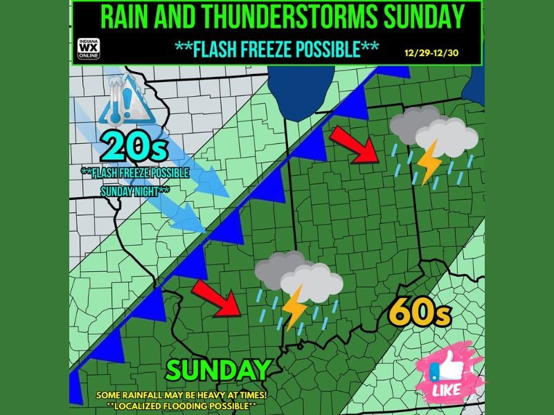
Forecasters warn that temperatures could plunge from the 60s on Sunday into the 20s overnight, setting up conditions where wet roads freeze instantly, creating treacherous travel across the state.
Thunderstorms and Heavy Rain Expected First
Sunday will begin unusually warm for late December, with temperatures climbing into the 50s and 60s statewide. Showers and thunderstorms are likely throughout the day, with some storms capable of:
- Small hail
- Gusty winds
- Locally heavy rainfall
- Localized flooding in low-lying areas
The Storm Prediction Center has introduced a 1/5 marginal severe weather risk for areas south of US-24, meaning a few storms could become strong but widespread severe weather is not expected.
Arctic Front Triggers Rapid Temperature Drop
By Sunday night, a strong Arctic front will sweep across Indiana, causing temperatures to drop sharply by 30–40 degrees within hours. Many areas could fall from the mid-60s to the low-20s before sunrise Monday.
This fast-moving cold air will reach the state before roadways are able to dry, dramatically increasing the risk of a flash freeze.
Flash Freeze Possible Sunday Night
Forecasters emphasize that a flash freeze is possible statewide, especially in areas that receive heavy rainfall during the afternoon and evening.
A flash freeze occurs when:
- Temperatures fall below freezing rapidly, and
- Wet surfaces instantly turn to ice
This can create slick roads, sidewalks, and parking lots, and may catch drivers off guard overnight and early Monday morning.
The map shows the dividing line clearly:
- 60s across southern and central Indiana Sunday afternoon
- 20s flooding into western and northern Indiana Sunday night
The sharp thermal gradient underscores how quickly conditions may deteriorate.
Travel Impacts and Safety Advice
With post-holiday travel still underway, officials urge residents to monitor conditions closely. Drivers should expect:
- Rapidly changing road conditions
- Black ice formation overnight
- Icy bridges and overpasses first
- Reduced visibility in heavier rain or storms
If possible, avoid late-night travel Sunday into early Monday.
Looking Ahead
The cold air will remain in place through Monday, keeping highs below freezing in many areas. Conditions are expected to improve slowly into midweek. For continued updates on Indiana’s rapidly changing weather pattern, follow NapervilleLocal.com for breaking forecasts and alerts.

I’ve lived in Naperville long enough to see how quickly our community changes — from new developments downtown to sudden shifts in our Midwest weather. Reporting on Naperville news and daily forecasts gives me the chance to keep neighbors informed about what really matters. My goal is simple: deliver clear, timely updates so you always know what’s happening in our city and what to expect from the skies above.