
Indiana Faces Snow Squalls and Graupel Threat Friday Afternoon With Sudden Whiteouts and Gusty Winds Possible
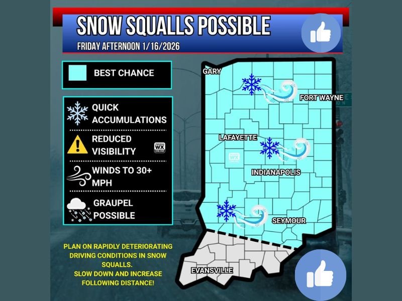
INDIANA — Parts of Indiana could experience snow squalls and heavy graupel showers Friday afternoon, a setup capable of producing sudden bursts of snow, rapid visibility drops, and gusty winds, according to the latest weather guidance shown in the forecast graphic.
The threat is not for a long-duration snowstorm, but rather fast-moving, high-impact snow squalls that can quickly turn roads hazardous with little warning.
Where Snow Squalls Are Most Likely
The forecast map highlights much of central and northern Indiana as having the best chance for snow squalls, including areas near:
- Gary
- Lafayette
- Indianapolis
- Fort Wayne
- Seymour
Southern Indiana, including areas near Evansville, appears to have a lower likelihood based on the shaded risk area.
What Makes Snow Squalls Dangerous
Snow squalls are short-lived but intense bursts of winter weather. According to the provided data, expected impacts include:
- Quick snow accumulations
- Reduced visibility, potentially dropping suddenly
- Wind gusts exceeding 30 mph
- Graupel showers, which can resemble small hail
These conditions can develop and dissipate rapidly, making them especially dangerous for drivers who may not expect winter weather to worsen so quickly.
Graupel Explained
Graupel forms through a process known as riming, where snowflakes fall through super-cooled water droplets that freeze onto the snowflake, creating a soft, icy coating.
Although graupel can look like small hail, it is not true hail. It is sometimes referred to as:
- “Popcorn snow”
- “Dippin’ Dots snow”
In heavier showers, graupel can accumulate quickly and contribute to slick road surfaces.
Additional Hazards Possible
The forecast discussion also notes that isolated lightning strikes cannot be ruled out in the strongest snow or graupel showers — a sign of unusually strong atmospheric instability for winter precipitation.
Travel Conditions Could Deteriorate Quickly
Drivers are urged to be alert for rapidly changing conditions Friday afternoon. Snow squalls are known to cause:
- Sudden whiteouts
- Chain-reaction crashes
- Rapid ice formation on untreated roads
The guidance emphasizes slowing down and increasing following distance if caught in a snow squall.
Bottom Line
Indiana faces a risk of snow squalls Friday afternoon, with quick accumulations, graupel, gusty winds, and sharply reduced visibility possible across much of the state. While totals may be light, the impact on travel could be significant due to how fast conditions can deteriorate.
NapervilleLocal.com will continue monitoring significant weather events across the region and provide updates as conditions evolve.

I’ve lived in Naperville long enough to see how quickly our community changes — from new developments downtown to sudden shifts in our Midwest weather. Reporting on Naperville news and daily forecasts gives me the chance to keep neighbors informed about what really matters. My goal is simple: deliver clear, timely updates so you always know what’s happening in our city and what to expect from the skies above.