
Indiana Forecast Warns of Light Freezing Rain and Slick Travel Friday, With Up to 0.10″ Ice Accretion Expected in Far Northern and Eastern Counties
Indiana — Residents in northeast Indiana are being advised to prepare for light freezing rain and drizzle early Friday morning, with the potential for 0.05″ to 0.10″ of ice accretion in the far northern and eastern counties, according to the latest regional forecast. While officials stress that this is not an ice storm, even a thin glaze may create slippery roads and hazardous travel conditions through midday.
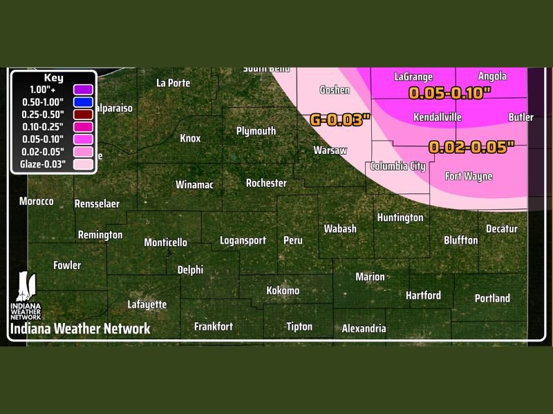
Light Ice Accumulation Expected in Steuben, LaGrange, Angola, and Surrounding Areas
Forecasters report that the highest ice totals are expected across Steuben County, LaGrange County, and the Angola area, where up to 0.10″ of ice could accumulate on untreated surfaces. Additional icing amounts of 0.02″ to 0.05″ are projected for cities such as Fort Wayne, Columbia City, and surrounding communities.
The map provided by the Indiana Weather Network shows a narrow but impactful corridor of light icing extending across northern Indiana. While the amounts remain relatively small, meteorologists emphasize that even 0.03″ of glaze can quickly transform roads and sidewalks into slick, hazardous surfaces.
Officials reiterate that power outages and tree damage are not expected, as totals fall below thresholds typically associated with major ice events. The primary concern is travel safety, especially during the early commute hours.
Early Morning Timing May Cause Commuting Issues
The timing of the event is a key factor in the travel risks. Freezing rain is forecast to begin between 2 a.m. and 4 a.m. Friday, continuing into the late morning and tapering off by early afternoon. With temperatures hovering near freezing during the onset, roads may become slick before salt trucks and crews can respond.
Drivers traveling through northern Indiana should anticipate:
- Icy patches on bridges and overpasses
- Reduced traction on untreated roads
- Longer stopping distances
- Potential delays for school transportation and morning commuters
Meteorologists caution that the event may appear minor at first glance but could still create unexpected hazards for anyone on the road during the early hours of the day.
Communities Advised to Prepare for Slippery Conditions
Residents are encouraged to take standard winter precautions, especially in areas highlighted within the 0.05″–0.10″ impact zone. Forecasters recommend:
- Allowing extra travel time Friday morning
- Using winter-ready tires and driving slowly on rural roads
- Checking updated local forecasts before leaving home
- Watching for black ice, which may not be visible but can be extremely slippery
Local officials also note that temperatures should rise gradually by late morning, helping reduce ice formation and improve road conditions heading into the afternoon.
Forecast Signals a Cautionary but Manageable Winter Weather Event
Although not classified as a significant winter storm, the light icing event serves as a reminder that even small amounts of freezing rain can disrupt travel across Indiana’s northern counties. With moisture expected to remain light and power impacts unlikely, the main message from meteorologists is focused on cautious driving and awareness during the morning hours.
Additional updates will be issued if the temperature trend shifts or if icing totals appear likely to exceed initial projections. For continued winter weather updates, travel advisories, and Midwest regional forecasts, visit NapervilleLocal.com for the latest information.

I’ve lived in Naperville long enough to see how quickly our community changes — from new developments downtown to sudden shifts in our Midwest weather. Reporting on Naperville news and daily forecasts gives me the chance to keep neighbors informed about what really matters. My goal is simple: deliver clear, timely updates so you always know what’s happening in our city and what to expect from the skies above.